East Greenwich Township, New Jersey
| East Greenwich Township, New Jersey | |
|---|---|
| Township | |
| Township of East Greenwich | |

Death of the Fox Inn
|
|
 East Greenwich Township highlighted in Gloucester County. Inset map: Gloucester County highlighted in the State of New Jersey. |
|
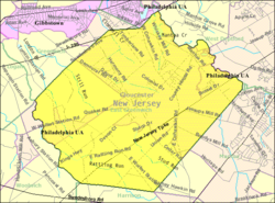
 Census Bureau map of East Greenwich Township, New Jersey |
|
| Coordinates: 39°47′26″N 75°14′26″W / 39.790519°N 75.240592°WCoordinates: 39°47′26″N 75°14′26″W / 39.790519°N 75.240592°W | |
| Country | |
| State |
|
| County |
|
| Incorporated | February 10, 1881 |
| Government | |
| • Type | Township |
| • Body | Township Committee |
| • Mayor | Dale L. Archer (term ends December 31, 2016) |
| • Clerk | Susan Costill |
| Area | |
| • Total | 14.922 sq mi (38.649 km2) |
| • Land | 14.440 sq mi (37.400 km2) |
| • Water | 0.482 sq mi (1.249 km2) 3.23% |
| Area rank | 175th of 566 in state 12th of 24 in county |
| Elevation | 62 ft (19 m) |
| Population (2010 Census) | |
| • Total | 9,555 |
| • Estimate (2015) | 10,380 |
| • Rank | 249th of 566 in state 11th of 24 in county |
| • Density | 661.7/sq mi (255.5/km2) |
| • Density rank | 418th of 566 in state 17th of 24 in county |
| Time zone | Eastern (EST) (UTC-5) |
| • Summer (DST) | Eastern (EDT) (UTC-4) |
| ZIP code | 08056 - Mickleton |
| Area code(s) | 856 Exchanges: 224, 423, 467, 478 |
| FIPS code | 3401519180 |
| GNIS feature ID | 0882141 |
| Website | www |
East Greenwich Township is a township in Gloucester County, New Jersey, United States. As of the 2010 United States Census, the township's population was 9,555, reflecting an increase of 4,125 (+76.0%) from the 5,430 counted in the 2000 Census, which had in turn increased by 172 (+3.3%) from the 5,258 counted in the 1990 Census.
East Greenwich Township was created by an act of the New Jersey Legislature on February 10, 1881, from the eastern part of Greenwich Township and the western part of Mantua Township.
According to the United States Census Bureau, the township had a total area of 14.922 square miles (38.649 km2), including 14.440 square miles (37.400 km2) of land and 0.482 square miles (1.249 km2) of water (3.23%).
Unincorporated communities, localities and place names located partially or completely within the township include Clarksboro, Hendricksons Mills, Mickleton, Middleton, Mount Royal, Tomlins, Warringtons Mills and Wolfert.
The 2010 United States Census counted 9,555 people, 3,262 households, and 2,645 families residing in the township. The population density was 661.7 per square mile (255.5/km2). The township contained 3,405 housing units at an average density of 235.8 per square mile (91.0/km2). The racial makeup of the township was 88.45% (8,451) White, 5.86% (560) Black or African American, 0.14% (13) Native American, 3.61% (345) Asian, 0.05% (5) Pacific Islander, 0.59% (56) from other races, and 1.31% (125) from two or more races. Hispanics or Latinos of any race were 3.02% (289) of the population.
...
Wikipedia
