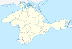
Dzhankoy
|
Dzhankoy Джанкой Canköy |
||
|---|---|---|
| City | ||
 |
||
|
||
| Location of Dzhankoy within Crimea | ||
| Coordinates: 45°42′31″N 34°23′36″E / 45.70861°N 34.39333°ECoordinates: 45°42′31″N 34°23′36″E / 45.70861°N 34.39333°E | ||
| Country | Disputed: | |
| Republic | Crimea | |
| Region | Dzhankoy city municipality | |
| Area | ||
| • Total | 26 km2 (10 sq mi) | |
| Elevation | 20 m (70 ft) | |
| Population (2014) | ||
| • Total | 38,622 | |
| • Density | 1,648.5/km2 (4,270/sq mi) | |
| Time zone | MSK (UTC+3) | |
| Postal code | 96100 — 96114 | |
| Area code(s) | +7-36564 | |
| Website | dzhankoy |
|
Dzhankoy, Jankoy (Ukrainian and Russian: Джанкóй, Crimean Tatar: Canköy) is a town of regional significance in the north of the Crimea. It also serves as administrative center of Dzhankoy Raion although it is not a part of the raion (district). Population: 38,622 (2014 Census).
The name Dzhankoy is often translated into English from Crimean Tatar as "spirit-village" (can — spirit, köy — village) -Canköy. But real meaning of this name is "new village": canköy < cañı köy (cañı is "new" in the northern dialect of Crimean Tatar).
In the city there are many types of industrial factories, some of which are: automobile, reinforced concrete, fabric, meat, and others. Dzhankoy also contains professional technical schools.
Dzhankoy serves as the administrative center of the Dzhankoy Raion. It is located about 93 kilometres (58 mi) from the Crimean capital, Simferopol. Two railroad lines, Solionoye ozero-Sevastopol and Armyansk-Kerch, cross Dzhankoy. In 1926, Dzhankoy was granted city status.
Dzhankoy is a transportation hub. Through the city pass two major railways of the peninsula as well as two major European highways. It has two railroad terminals - the central one, where only passenger and fast trains stop and the suburban one - where only suburban trains, known as elektrichki are allowed.
...
Wikipedia


