Dyer, Nevada
| Dyer, Nevada | |
|---|---|
| Census-designated place | |
 |
|
| Location within the state of Nevada | |
| Coordinates: 37°40′04″N 118°04′03″W / 37.66778°N 118.06750°WCoordinates: 37°40′04″N 118°04′03″W / 37.66778°N 118.06750°W | |
| Country | United States |
| State | Nevada |
| County | Esmeralda |
| Area | |
| • Total | 32.6 sq mi (84.4 km2) |
| • Land | 32.5 sq mi (84.2 km2) |
| • Water | 0.08 sq mi (0.2 km2) |
| Elevation | 4,880 ft (1,490 m) |
| Population (2010) | |
| • Total | 259 |
| • Density | 8/sq mi (3.1/km2) |
| Time zone | Pacific (PST) (UTC-8) |
| • Summer (DST) | PDT (UTC-7) |
| ZIP code | 89010 |
| FIPS code | 32-20700 |
| GNIS feature ID | 859604 |
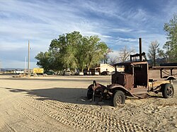
Dyer is an unincorporated community and census-designated place (CDP) in Fish Lake Valley, Esmeralda County, Nevada, United States. It had a population of 259 as of the 2010 census. The town serves the surrounding area's sparse rural population of mainly ranchers and indigenous Paiute people. The town has a gas station/store, cafe, post office and airport.
Dyer is located on State Route 264, near Nevada's border with California. It is 25 miles (40 km) south of U.S. Route 6 and 15 miles (24 km) north of Oasis, California.
The Köppen Climate System classifies the weather in this area as semi-arid, abbreviated BSk. This climate type occurs primarily on the periphery of true deserts in low-latitude semiarid steppe regions.
...
Wikipedia

