Dunhua
|
Dunhua 敦化市 · 돈화시 |
|
|---|---|
| County-level city | |

Dunhua in 2013
|
|
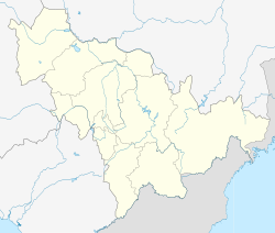
| Location in Jilin province | |
| Coordinates: 43°22′N 128°14′E / 43.367°N 128.233°ECoordinates: 43°22′N 128°14′E / 43.367°N 128.233°E | |
| Country | People's Republic of China |
| Province | Jilin |
| Prefecture | Yanbian |
| Seat | Minzhu Subdistrict |
| Area | |
| • Total | 11,963 km2 (4,619 sq mi) |
| Elevation | 505 m (1,657 ft) |
| Population | |
| • Total | 480,000 |
| • Density | 40/km2 (100/sq mi) |
| Time zone | China Standard (UTC+8) |
| Postal code | 133700 |
| Area code(s) | 0433 |
| Dunhua | |||||||
| Chinese | 敦化市 | ||||||
|---|---|---|---|---|---|---|---|
|
|||||||
| Chinese Korean name | |||||||
| Chosŏn'gŭl | 돈화시 | ||||||
|
|||||||
| South Korean name | |||||||
| Hangul | 둔화 시 | ||||||
|
|||||||
| Transcriptions | |
|---|---|
| Standard Mandarin | |
| Hanyu Pinyin | Dūnhuà Shì |
| Transcriptions | |
|---|---|
| Revised Romanization | Donhwa-si |
| McCune–Reischauer | Tonhwa-si |
| Transcriptions | |
|---|---|
| Revised Romanization | Dunhwa Si |
| McCune–Reischauer | Tunhwa Si |
Dunhua is a county-level city of the Yanbian Korean Autonomous Prefecture in southeastern Jilin province, People's Republic of China. It has more than 480,000 inhabitants (as of 2002) and was the capital of Balhae between 742−756, known at the time as "Junggyeong". During the Qing Dynasty it was called Áodōng (敖东) in Chinese and Odoli in Manchu.
Dunhua is situated amongst the Changbai Mountains, its administrative area spanning 42°42′−44°30′ N latitude and 127°28′−129°13′ E longitude, reaching a maximal north-south extent of 200 km (124 mi) and east-west width of 142 km (88 mi). Its total area of 11,957 km2 (4,617 sq mi) makes it, by area, the largest county-level city of the province.
Dunhua has a four-season, monsoon-influenced, humid continental climate (Köppen Dwb), with long, very cold winters, and short, but warm, humid summers. Spring and autumn constitute very short transitions with some, but usually not heavy, rainfall. The monthly 24-hour average temperature ranges from −16.6 °C (2.1 °F) in January to 20.1 °C (68.2 °F) in July, while the annual mean is 3.28 °C (37.9 °F) and a total precipitation of 632 mm (24.9 in), more than 60% of which falls from June through August.
Dunhua has four subdistricts, 11 towns, and 5 townships.
Subdistricts:
Towns:
Townships:
...
Wikipedia

