Dundee, Quebec
| Dundee | |
|---|---|
| Township municipality | |
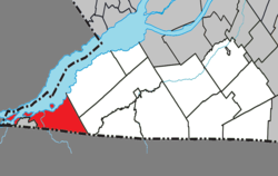
 Location within Le Haut-Saint-Laurent RCM |
|
| Location in southern Quebec | |
| Coordinates: 45°01′N 74°29′W / 45.02°N 74.48°WCoordinates: 45°01′N 74°29′W / 45.02°N 74.48°W | |
| Country |
|
| Province |
|
| Region | Montérégie |
| RCM | Le Haut-Saint-Laurent |
| Constituted | July 1, 1855 |
| Named for | Dundee |
| Government | |
| • Mayor | Jean Armstrong |
| • Federal riding | Beauharnois—Salaberry |
| • Prov. riding | Huntingdon |
| Area | |
| • Total | 84.40 km2 (32.59 sq mi) |
| • Land | 69.76 km2 (26.93 sq mi) |
| Population (2011) | |
| • Total | 408 |
| • Density | 5.8/km2 (15/sq mi) |
| • Pop 2006-2011 |
|
| • Dwellings | 336 |
| Time zone | EST (UTC−5) |
| • Summer (DST) | EDT (UTC−4) |
| Postal code(s) | J0S 1L0 |
| Area code(s) | 450 and 579 |
| Highways |
|
Dundee is a township municipality in Le Haut-Saint-Laurent Regional County Municipality in the Montérégie administrative region of Quebec, Canada. The population as of the Canada 2011 Census was 408. It is primarily an agricultural area consisting of dairy and grain farms.
Dundee is located in the southwestern corner of the Montérégie region of Quebec. The township is bordered on the south by the Canada–United States border, on the north-west by the Saint Lawrence River, and the Mohawk reserve of Akwesasne to the west. The Salmon River runs through the municipality in a northwesterly direction from the US border to the Saint Lawrence, where many islands also make up Dundee's total area.
The following locations reside within the municipality's boundaries:
The following waterways pass through or are situated within the municipality's boundaries:
...
Wikipedia

