Dunbar Township, Pennsylvania
| Dunbar Township | |
|---|---|
| Township | |

The Isaac Meason House, a historic house in the township
|
|
 Location of Dunbar Township in Fayette County |
|
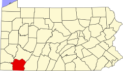
 Location of Fayette County in Pennsylvania |
|
| Country | United States |
| State | Pennsylvania |
| County | Fayette |
| Area | |
| • Total | 59.54 sq mi (154.2 km2) |
| • Land | 59.10 sq mi (153.1 km2) |
| • Water | 0.44 sq mi (1.1 km2) |
| Population (2010) | |
| • Total | 7,126 |
| • Density | 120.6/sq mi (46.6/km2) |
| Time zone | EST (UTC-4) |
| • Summer (DST) | EDT (UTC-5) |
| Area code(s) | 724 |
Dunbar Township is a township in Fayette County, Pennsylvania, United States. The population was 7,126 at the 2010 census, down from 7,562 at the 2000 census.
Dunbar Township includes the unincorporated communities of Dickerson Run, Liberty, Adelaide, Crossland, Juniata, Little Summit, Graham Crossing, Leisenring, Rogerstown, Trotter, Greenwood Heights, Wheeler, Fayette, Sitka, Bowest, Monarch, Mahoning, Hill Farm, Ferguson, Pechin, Brown Row, Hardy Hill, Factory Hill, Furnace Hill, and Irishtown.
The Isaac Meason House was designated a National Historic Landmark in 1971.
Dunbar Township is in north-central Fayette County. It is bordered to the north and east by the Youghiogheny River, except where it touches the city of Connellsville. The township surrounds the boroughs of Dunbar (near the township center) and Vanderbilt (in the northwest). Across the Youghiogheny, the township is bordered by the borough of South Connellsville to the northeast and by the borough of Dawson to the north.
According to the United States Census Bureau, the township has a total area of 59.54 square miles (154.21 km2), of which 59.10 square miles (153.06 km2) is land and 0.44 square miles (1.15 km2), or 0.74%, is water.
U.S. Route 119 crosses the township, leading northeast to Connellsville and southwest to Uniontown, the Fayette County seat.
As of the census of 2000, there were 7,562 people, 2,944 households, and 2,140 families residing in the township. The population density was 128.0 people per square mile (49.4/km²). There were 3,152 housing units at an average density of 53.3/sq mi (20.6/km²). The racial makeup of the township was 97.57% White, 1.52% African American, 0.12% Native American, 0.21% Asian, 0.04% from other races, and 0.54% from two or more races. Hispanic or Latino of any race were 0.32% of the population.
...
Wikipedia
