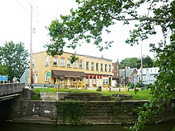
Dunbar, Pennsylvania
| Dunbar, Pennsylvania | |
|---|---|
| Borough | |

Dunbar's business district
|
|
 Location of Dunbar in Fayette County |
|
| Location of Dunbar in Pennsylvania | |
| Coordinates: 39°58′36″N 79°36′53″W / 39.97667°N 79.61472°WCoordinates: 39°58′36″N 79°36′53″W / 39.97667°N 79.61472°W | |
| Country | United States |
| State | Pennsylvania |
| County | Fayette |
| Established | 1857 |
| Government | |
| • Mayor | Norman Gordon |
| Area | |
| • Total | 0.6 sq mi (2 km2) |
| Population (2010) | |
| • Total | 1,042 |
| • Density | 1,700/sq mi (670/km2) |
| Time zone | EST (UTC-4) |
| • Summer (DST) | EDT (UTC-5) |
| Area code(s) | 724 |
Dunbar is a borough in Fayette County, Pennsylvania, United States. The population was 1,042 at the 2010 census, down from 1,219 at the 2000 census.
Dunbar is named for Col. John Dunbar, who commanded an English force at this point and was defeated by the French and Indians.
Dunbar is located in north-central Fayette County at 39°58′36″N 79°36′53″W / 39.97667°N 79.61472°W, in the valley of Dunbar Creek, a tributary of the Youghiogheny River. It is 5 miles (8 km) south of Connellsville via Woodvale Street and U.S. Route 119. Uniontown, the county seat, is 8 miles (13 km) to the southwest.
According to the United States Census Bureau, Dunbar has a total area of 0.606638 square miles (1.571185 km2), all of it land.
As of the census of 2000, there were 1,219 people, 513 households, and 343 families residing in the borough. The population density was 1,879.0 people per square mile (724.1/km²). There were 576 housing units at an average density of 887.9 per square mile (342.1/km²). The racial makeup of the borough was 99.26% White, 0.41% African American, 0.08% Native American, 0.08% Asian, and 0.16% from two or more races.
...
Wikipedia


