Duchesne County
| Duchesne County, Utah | |
|---|---|

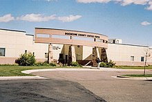
Duchesne County Courthouse in Duchesne
|
|
 Location in the U.S. state of Utah |
|
 Utah's location in the U.S. |
|
| Founded | 1915 |
| Named for | Duchesne River |
| Seat | Duchesne |
| Largest city | Roosevelt |
| Area | |
| • Total | 3,256 sq mi (8,433 km2) |
| • Land | 3,241 sq mi (8,394 km2) |
| • Water | 15 sq mi (39 km2), 0.50% |
| Population (est.) | |
| • (2015) | 20,862 |
| • Density | 5.7/sq mi (2.2/km2) |
| Congressional district | 1st |
| Time zone | Mountain: UTC−7/−6 |
| Website | duchesne |
Duchesne County (/duːˈʃeɪn/ doo-SHAYN) is a county located in the U.S. state of Utah. As of the 2010 census, the population was 18,607. Its county seat is Duchesne, and the largest city is Roosevelt.
Its name is of uncertain origin, but the holding theory is that it was named from the river that runs through town and may have been named by fur trappers in the 1820s in honor of Mother Rose Philippine Duchesne, founder of the School of the Sacred Heart near St. Louis, Missouri, although other theories as to the name exist.
According to the U.S. Census Bureau, the county has a total area of 3,256 square miles (8,430 km2), of which 3,241 square miles (8,390 km2) is land and 15 square miles (39 km2) (0.5%) is water. The northern part of the county contains a large majority of the Uinta Mountains. The highest natural point in Utah, Kings Peak at 13,528 feet (4,123 m), is located in Duchesne County.
As of the census of 2010, there were 18,607 people, 6,003 households, and 4,703 families residing in the county. The population density was 5.7 people per square mile (2/km²). There were 6,988 housing units at an average density of 2 per square mile (1/km²). The racial makeup of the county was 89.15% White, 0.24% Black or African American, 4.53% Native American, 0.28% Asian, 0.27% Pacific Islander, 2.64% from other races, and 2.89% from two or more races. 6.00% of the population were Hispanic or Latino of any race.
...
Wikipedia
