DubaiSat-1

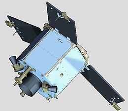
An artist rendering of DubaiSat-1
|
|
| Mission type | Remote sensing |
|---|---|
| Operator | Mohammed Bin Rashid Space Centre |
| COSPAR ID | 2009-041B |
| SATCAT no. | 35682 |
| Website | mbrsc |
| Mission duration | 5 years |
| Spacecraft properties | |
| Bus | SI-200 |
| Manufacturer | Satrec Initiative |
| Launch mass | ~200 kilograms (440 lb) |
| Dimensions | 1,200 by 1,200 millimetres (47 in × 47 in) (Hexagonal) |
| Power | 330 watts |
| Start of mission | |
| Launch date | July 29, 2009, 18:46 UTC |
| Rocket | Dnepr |
| Launch site | Baikonur 109/95 |
| Contractor | ISC Kosmotras |
| Orbital parameters | |
| Reference system | Geocentric |
| Regime | Sun-Synchronous |
| Perigee | 669.4 kilometres (415.9 mi) |
| Apogee | 688.3 kilometres (427.7 mi) |
| Inclination | 98.13 degrees |
| Period | 98.2 minutes |
| Main camera | |
| Name | DMAC |
| Wavelengths |
Pan: 420-720 nm MS1: 420-510 nm (Blue) MS2: 510-580 nm (Green) MS3: 600-720 nm (Red) MS4: 760-890 nm (Near Infrared) |
| Resolution | 2.5 metres (8 ft 2 in) (Pan) 5 metres (16 ft) (MS) |
DubaiSat-1 is a remote sensing Earth observation satellite built by the Emirates Institution for Advanced Science and Technology (EIAST) under an agreement with Satrec Initiative, a satellite manufacturing company in South Korea. The earth observation satellite was designed and developed by Satrec Initiative, with participation from EIAST engineers.
DubaiSat-1 was launched on July 29, 2009 into a 680 km altitude sun-synchronous polar orbit from the Baikonur launch site in Kazakhstan, along with several other satellites on board the Dnepr launch vehicle.
DubaiSat-1 observes the earth at a Low Earth orbit (LEO) and generates high-resolution optical images at 2.5m in panchromatic and at 5m in multispectral bands. These images provide decision makers in the UAE as well as EIAST clients with a valuable tool for a wide range of applications including infrastructure development, urban planning, and environment monitoring and protection. DubaiSat-1 images are also useful for promoting geosciences and remote sensing research in the region, and for supporting different scientific disciplines in private and academic sectors.
For example, DubaiSat-1 images have been used, to monitor progress on the Dubai World Megaproject, Palm Islands, and the Al Maktoum International Airport.
The United Nations also used DubaiSat-1 images to monitor relief efforts following the 2011 Tōhoku earthquake and tsunami in Japan.
...
Wikipedia
