Dreschvitz
| Dreschvitz | ||
|---|---|---|

Church
|
||
|
||
| Coordinates: 54°23′N 13°19′E / 54.383°N 13.317°ECoordinates: 54°23′N 13°19′E / 54.383°N 13.317°E | ||
| Country | Germany | |
| State | Mecklenburg-Vorpommern | |
| District | Vorpommern-Rügen | |
| Municipal assoc. | West-Rügen | |
| Government | ||
| • Mayor | Olaf Braumann | |
| Area | ||
| • Total | 22.52 km2 (8.70 sq mi) | |
| Elevation | 10 m (30 ft) | |
| Population (2015-12-31) | ||
| • Total | 755 | |
| • Density | 34/km2 (87/sq mi) | |
| Time zone | CET/CEST (UTC+1/+2) | |
| Postal codes | 18573 | |
| Dialling codes | 038306 | |
| Vehicle registration | RÜG | |
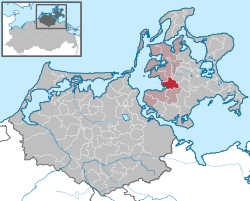
Dreschvitz is a municipality in southwest Vorpommern-Rügen, a district on the island of Rügen in Mecklenburg-Vorpommern, Germany. It is managed from the Amt of West-Rügen with its head offices in the village of Samtens.
The village lies on the lagoon of Kubitzer Bodden. The villages of Bußvitz, Dußvitz, Güttin, Landow, Mölln, Ralow and Rugenhof all belong to the municipality of Dreschvitz. The island of Liebitz also lies within its territory.
The village was first mentioned in the records in 1314 on an entry in an old deed of ownership. Originally a dead-end village (Gassendorf) with four large estates, Dreschvitz is only 3 kilometres from the old so-called Salt Road (Salzstraße).
Until 1326, the settlement was part of the Principality of Rügen and, thereafter, of the Duchy of Pomerania.
Under the Treaty of Westphalia in 1648, Rügen, and therefore Dreschvitz, ended up under Swedish rule, having formerly been part of the Duchy of Pomerania. In 1815, the parish along with the rest of West Pomerania went into the Prussian Province of Pomerania.
In 1818, Dreschvitz became part of the shire county of Rügen. From 1952-1955 it was part of the County of Putbus. From 1955 to 1990, the village was part of the County of Rügen in the and the state of Mecklenburg-Western Pomerania. In 1990, it was renamed the shire county (Landkreis) of Rügen, but this was finally merged in 2011 into the new county of Vorpommern-Rügen.
...
Wikipedia


