Dreher Shoals Dam
| Lake Murray Dam | |
|---|---|

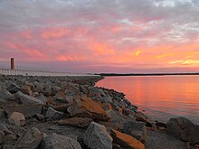
Looking down the dam from the Irmo side.
|
|
| Official name | Dreher Shoals Dam |
| Location | Lexington County, near Lexington, South Carolina |
| Coordinates | 34°03′12″N 81°13′04″W / 34.0533°N 81.2178°WCoordinates: 34°03′12″N 81°13′04″W / 34.0533°N 81.2178°W |
| Construction began | 1927 |
| Opening date | 1930 |
| Operator(s) | South Carolina Electric & Gas Company |
| Dam and spillways | |
| Type of dam | Embankment, earth-fill with RCC gravity toe |
| Impounds | Saluda River |
| Height | 200 ft (61 m) |
| Length | 7,800 ft (2,400 m) |
| Reservoir | |
| Creates | Lake Murray |
| Total capacity | 2,200,000 acre·ft (2.7 km3) |
| Catchment area | 2,420 sq mi (6,300 km2) |
| Surface area | 50,000 acres (200 km2) |
| Power station | |
| Turbines | 5 x vertical Francis turbines (3 @ 32.5 MW, 1 @ 42.3 MW, 1 @ 67.5 MW) |
| Installed capacity | 207 MW |
| Annual generation | 245,000,000 kWh |
The Saluda Dam or Saluda River Dam, officially the Dreher Shoals Dam, commonly referred to as the Lake Murray Dam, is an earthen embankment dam located approximately 10 miles (15 km) west of Columbia, South Carolina on the Saluda River. Construction on the dam began in 1927 and was completed in 1930. The purpose of the dam is flood control, hydroelectricity, recreation and water supply. At the time of its completion, the Saluda Dam was the world's largest earthen dam, creating the world's largest man-made lake, Lake Murray. In 2005, construction on a 213 ft (65 m). tall roller-compacted concrete (RCC) dam was completed at the toe of the original dam in order to mitigate an earthquake-caused dam failure.
South Carolina Highway 6 crosses over the dam and is used as a fast connection between the towns of Lexington and Irmo. The yearly football game between rival Lexington High School and Irmo High School is often called "The Battle of the Dam".
The original Saluda Dam is a 7,800 ft (2,400 m). long, 213-foot (65 m)-high earthen-embankment dam. The dam contains a 2,900 ft (880 m). long emergency spillway controlled by six steel tainter gates. The back-up dam located at the original dam's toe and is a 2,300 ft (700 m). long, 213-foot (65 m)-high roller-compacted concrete dam. Rock-fill embankment sections also exist on the south and north ends of the back up dam, making a total length of 5,700 ft (1,700 m).
...
Wikipedia
