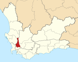
Drakenstein Municipality
| Drakenstein | ||
|---|---|---|
| Local municipality | ||
|
||
 Location in the Western Cape |
||
| Coordinates: 33°30′S 19°00′E / 33.500°S 19.000°ECoordinates: 33°30′S 19°00′E / 33.500°S 19.000°E | ||
| Country | South Africa | |
| Province | Western Cape | |
| District | Cape Winelands | |
| Seat | Paarl | |
| Wards | 31 | |
| Government | ||
| • Type | Municipal council | |
| • Mayor | Conrad Poole (DA) | |
| Area | ||
| • Total | 1,538 km2 (594 sq mi) | |
| Population (2011) | ||
| • Total | 251,262 | |
| • Density | 160/km2 (420/sq mi) | |
| Racial makeup (2011) | ||
| • Black African | 22.7% | |
| • Coloured | 62.5% | |
| • Indian/Asian | 0.4% | |
| • White | 13.5% | |
| First languages (2011) | ||
| • Afrikaans | 75.0% | |
| • Xhosa | 16.7% | |
| • English | 5.1% | |
| • Other | 3.2% | |
| Time zone | SAST (UTC+2) | |
| Municipal code | WC023 | |
Drakenstein Municipality is a local municipality located within the Cape Winelands District Municipality, in the Western Cape province of South Africa. As of 2011[update] it had a population of 251,262. Its municipality code is WC023.
The municipality covers a total area of 1,538 square kilometres (594 sq mi) in the valley of the Berg River to the west of the Boland mountain ranges. It stretches about 75 kilometres (47 mi) from Saron in the north to beyond Paarl in the south. It abuts on the Witzenberg Municipality and Breede Valley Municipality to the east, the Stellenbosch Municipality to the south, the City of Cape Town and the Swartland Municipality to the west, and the Bergrivier Municipality to the north.
According to the 2011 census the municipality has a population of 251,262 people in 59,774 households. Of this population, 62.5% describe themselves as "Coloured", 22.7% as "Black African", and 13.5% as "White". The first language of 75.0% of the population is Afrikaans, while 16.7% speak Xhosa and 5.1% speak English.
...
Wikipedia

