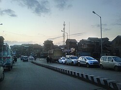
Downtown Srinagar
| Downtown (Srinagar) | |
|---|---|

View of Downtown from Zaina Kadal Bridge
|
|
| Location in Jammu and Kashmir, India | |
| Coordinates: 34°5′N 74°47′E / 34.083°N 74.783°ECoordinates: 34°5′N 74°47′E / 34.083°N 74.783°E | |
| District | Srinagar district |
| Settled | Ancient |
| Elevation | 1,585 m (5,200 ft) |
| Languages | |
| • Official | Kashmiri |
| • Official | Urdu |
| Time zone | IST (UTC+5:30) |
| Distance from Delhi | 837.4 kilometres (520.3 mi) |
| Distance from Mumbai | 2,192.6 kilometres (1,362.4 mi) |
Downtown, popularly known as Shehr-e-Khaas, is a notable area in the municipality of Srinagar. It is the largest and the most densely populated area in the city of Srinagar. The area is mostly located on the banks of Jhelum river about 5 km from city center. The area is considered as the core point in the city as the first inhabitants of the Srinagar lived here. The area reflects the images of old city of Srinagar. The historical buildings and monuments in the area reflect the design of old times. The residential homes are depicted to be constructed from late-19th century to early-20th century. Many key monuments like Jamia Masjid, Khanqah-e-moula Maharaj Gangh and shrines have been built famous rulers of Kashmir.
The area was settled more than 2000 years ago in 3rd century BC by Raja Pranavsarena. The area is the hub of the historical monuments made by the famous rulers of Kashmir. The historical monuments include Jamia Masjid in Nowhatta, Khanqah-e-Moula in zana kadal Aali Masjid in Eidgah, Maharaj Ganj tomb in Maharaj Ganj, Pathar (stone) Masjid in Nawabazar, and Sheikh Abdul Qadir Jeelani's shrine in Khanyar. Moreover, the Roza Bal shrine which is believed by the Ahmadaya community to be tomb of Jesus Christ is also situated in the area, nevertheless the view point is disagreed by the caretakers of this shrine.
The area is located at 34°05′00″N 74°47′00″E / 34.0833°N 74.7833°E at an elevation of 1585 meters above mean sea level in Srinagar.
...
Wikipedia


