Dover, England
| Dover | |
|---|---|
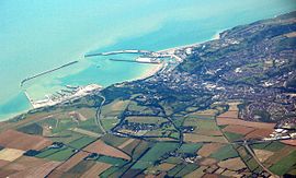
 Aerial view of Dover Harbour |
|
| Dover shown within Kent | |
| Population | 31,022 (2011 Census) |
| OS grid reference | TR315415 |
| • London | 77.8 miles (125.2 km) |
| District | |
| Shire county | |
| Region | |
| Country | England |
| Sovereign state | United Kingdom |
| Post town | DOVER |
| Postcode district | CT16, CT17 |
| Dialling code | 01304 |
| Police | Kent |
| Fire | Kent |
| Ambulance | South East Coast |
| EU Parliament | South East England |
| UK Parliament | |
Dover (/ˈdoʊvər/; French: Douvres) is a town and major ferry port in the home county of Kent, in South East England. It faces France across the strait of Dover, the narrowest part of the English Channel, and lies south-east of Canterbury; east of Kent's county town Maidstone; and north-east along the coastline from Dungeness and Hastings. The town is the administrative centre of the Dover District and home of the Dover Calais ferry through the Port of Dover. The surrounding chalk cliffs are known as the White Cliffs of Dover.
Its strategic position has been evident throughout its history: archaeological finds have revealed that the area has always been a focus for peoples entering and leaving Britain. The name of the town derives from the name of the river that flows through it, the River Dour. The town has been inhabited since the Stone Age according to archaeological finds, and Dover is one of only a few places in Britain – London, Edinburgh, and Cornwall being other examples – to have a corresponding name in the French language, Douvres.
...
Wikipedia

