Doncaster, Victoria
|
Doncaster Melbourne, Victoria |
|||||||||||||
|---|---|---|---|---|---|---|---|---|---|---|---|---|---|

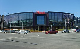
The exterior of Westfield Doncaster
|
|||||||||||||
| Coordinates | 37°47′13″S 145°07′26″E / 37.787°S 145.124°ECoordinates: 37°47′13″S 145°07′26″E / 37.787°S 145.124°E | ||||||||||||
| Population | 18,359 (2011) | ||||||||||||
| • Density | 2,063/km2 (5,343/sq mi) | ||||||||||||
| Established | 1860s | ||||||||||||
| Postcode(s) | 3108 | ||||||||||||
| Area | 8.9 km2 (3.4 sq mi) | ||||||||||||
| Location | 17 km (11 mi) from Melbourne | ||||||||||||
| LGA(s) | City of Manningham | ||||||||||||
| State electorate(s) | |||||||||||||
| Federal Division(s) | Menzies | ||||||||||||
|
|||||||||||||
Doncaster is a suburb of Melbourne, Victoria, Australia, 17 km East of Melbourne's Central Business District. Its local government area is the City of Manningham. At the 2011 Census, Doncaster had a population of 18,359.
The suburb, locally known as "Donny", just as its namesake in the UK, is situated on 8.9 km2 of land, around the top of the 120 m high Doncaster Hill. The suburb consists of a central area along the top of Doncaster Hill, which includes several historical buildings along Doncaster Road, the Westfield Doncaster Shopping Centre and surrounding high-rise apartments, while the rest of the suburb is typical of many of Melbourne's eastern suburbs, with extensive low-density housing. Today the suburb is perhaps most notable for its shopping centre, one of the largest in Australia.
The border of the suburb follows the Koonung Creek from Doncaster Road, along the south of the suburb to Wetherby Road, which, with Victoria Street, forms the eastern border. The northern border follows Ruffey Creek, Williamsons Road, Manningham Road and Ayr Street, to the junction of the Koonung Creek and Doncaster Road.
In 1841 Frederic Unwin, a Sydney solicitor, bought 5,120 acres (20.7 km2) of land, including most of the present suburb of Doncaster, from the Crown for one pound an acre under the terms of the short-lived Special Survey regulations. The area was sometimes known as Unwin's Special Survey.
The Doncaster region was settled in the 1860s and 1870s, predominantly by German settler orchardists. The German community was named Waldau, but the name Doncaster gradually became commonly accepted. A Lutheran church was the first one in Doncaster in 1858. A Lutheran school opened in 1860 and a denominational school in 1861. Doncaster Post Office opened on 17 May 1860.
...
Wikipedia

