Balwyn North, Victoria
|
Balwyn North Melbourne, Victoria |
|||||||||||||
|---|---|---|---|---|---|---|---|---|---|---|---|---|---|

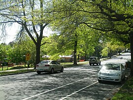
Leafy green trees provide a canopy over Bulleen Road
|
|||||||||||||
| Coordinates | 37°47′37″S 145°5′11″E / 37.79361°S 145.08639°ECoordinates: 37°47′37″S 145°5′11″E / 37.79361°S 145.08639°E | ||||||||||||
| Population | 20,317 (2011 census) | ||||||||||||
| • Density | 2,283/km2 (5,910/sq mi) | ||||||||||||
| Postcode(s) | 3104 | ||||||||||||
| Area | 8.9 km2 (3.4 sq mi) | ||||||||||||
| Location | 10 km (6 mi) from Melbourne | ||||||||||||
| LGA(s) | City of Boroondara | ||||||||||||
| State electorate(s) | Kew | ||||||||||||
| Federal Division(s) | Kooyong | ||||||||||||
|
|||||||||||||
Balwyn North, also known as North Balwyn, is a suburb of Melbourne, Victoria, Australia, 10 km east of Melbourne's Central Business District. Its local government area is the City of Boroondara. At the 2011 Census, Balwyn North had a population of 20,317.
The north-west part of the suburb is known as Bellevue and the south-east part is known as Greythorn.
Balwyn North was one of the first Melbourne suburbs to be developed according to the pattern of postwar suburbia, with expansive, quiet residential areas designed as family homes and relatively few business districts. The original route of Bulleen Road began at the present-day corner of Kilby Road and Burke Road, but by the 1900s, its route had changed to its present-day alignment. This was a result of Elgar's Special Survey, which dragged the alignment of Burke Road further west, resulting in the surrounding road network being forced to adjust.
A Balwyn North Post Office opened on 1 April 1937. This was renamed Burke Road in 1941, when a new Balwyn North office opened at its current location. The Greythorn Post Office opened in 1951. The suburb was lampooned in the 1974 song by Australian band The Skyhooks, Balwyn Calling.
Greythorn was developed later than North Balwyn, but has had residents living there since the 1830s, when the Maughan and Towt families bought large tracts of land in the area. Present-day Greythorn Road was formerly known as 'Towt's Road' but renamed to 'Whitethorn Road', after the many whitethorn hedges that had been planted along it. To avoid confusion with Whitehorse Road, the name was changed again to 'Greythorn' some time in the 1920s. The area around Greythorn Park was a wildlife sanctuary from 1938 until 1954, when the area between the park and Greythorn Road was subdivided and sold for housing. Greythorn Primary School was opened in 1953 and occupies a site covering approximately two hectares.
...
Wikipedia

