Dixville, Quebec
| Dixville | |
|---|---|
| Municipality | |
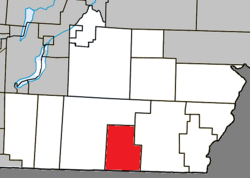
 Location within Coaticook RCM. |
|
| Location in southern Quebec. | |
| Coordinates: 45°04′N 71°46′W / 45.067°N 71.767°WCoordinates: 45°04′N 71°46′W / 45.067°N 71.767°W | |
| Country |
|
| Province |
|
| Region | Estrie |
| RCM | Coaticook |
| Constituted | September 27, 1995 |
| Government | |
| • Mayor | Réal Ouimette |
| • Federal riding | Compton—Stanstead |
| • Prov. riding | Saint-François |
| Area | |
| • Total | 77.40 km2 (29.88 sq mi) |
| • Land | 76.64 km2 (29.59 sq mi) |
| Population (2011) | |
| • Total | 710 |
| • Density | 9.3/km2 (24/sq mi) |
| • Pop 2006-2011 |
|
| • Dwellings | 291 |
| Time zone | EST (UTC−5) |
| • Summer (DST) | EDT (UTC−4) |
| Postal code(s) | J0B 1P0 |
| Area code(s) | 819 |
| Highways |
|
| Website | www |
Dixville is a municipality in Quebec in the regional county municipality of Coaticook and the region of Eastern Township. It is named after Dick Baldwin, a local pioneer who built a mill and whose first name is pronounced Dix.
The name Saint-Mathieu-de-Dixville was used in the past. It may be the name of the local Roman Catholic church.
Population trend:
There is a dam in the municipality at 45° 04' 07" 71° 46' 15"
...
Wikipedia

