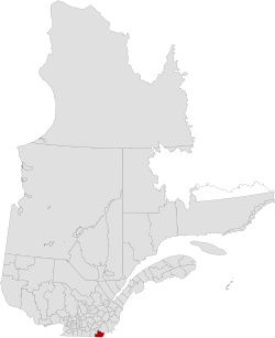
Coaticook Regional County Municipality
| Coaticook | |
|---|---|
| Regional county municipality | |
 |
|
| Coordinates: 45°08′N 71°48′W / 45.133°N 71.800°WCoordinates: 45°08′N 71°48′W / 45.133°N 71.800°W | |
| Country |
|
| Province |
|
| Region | Estrie |
| Effective | January 1, 1982 |
| County seat | Coaticook |
| Government | |
| • Type | Prefecture |
| • Prefect | Réjean Masson |
| Area | |
| • Total | 1,354.70 km2 (523.05 sq mi) |
| • Land | 1,338.98 km2 (516.98 sq mi) |
| Population (2011) | |
| • Total | 18,847 |
| • Density | 14.1/km2 (37/sq mi) |
| • Pop 2006-2011 |
|
| Time zone | EST (UTC−5) |
| • Summer (DST) | EDT (UTC−4) |
| Area code(s) | 819 |
| Website | www |
Coaticook is a regional county municipality in the Estrie region of Quebec, Canada. The seat is Coaticook.
On September 3, 1783, as a result of the signing of the Treaty of Paris the American Revolutionary War ended with Great Britain. Quebec's border with the states of Vermont and New Hampshire was established at 45 degrees north latitude.
There are 12 subdivisions within the RCM:
Mother tongue language from Canada 2006 Census
Highways and numbered routes that run through the municipality, including external routes that start or finish at the county border:
...
Wikipedia
