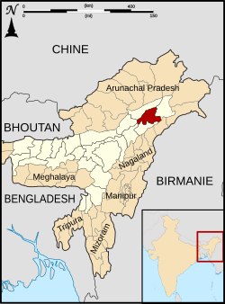
Dibrugarh district
|
Dibrugarh district ডিব্ৰুগড় জিলা |
|
|---|---|
| District of Assam | |
 Location of Dibrugarh district in Assam |
|
| Country | India |
| State | Assam |
| Administrative division | Dibrugarh Division |
| Headquarters | Dibrugarh |
| Tehsils | 1. Dibrugarh Town 2. Moderkhat 3. Lahowal 4. Rohmoria 5. Laruwa 6. Jamira 7. Mancotta-Khanikar 8. Moran 9. Sepon 10. Lengeri 11. Khowang 12. Tengakhat 13. Tipling 14. Kheremia 15. Chabua Pulunga 16. Bogdung 17. Gharbandi 18. Sasoni 19. Joypur 20. Fakial 21. Tingkhong |
| Government | |
| • Lok Sabha constituencies | 1. Dibrugarh |
| • Assembly seats | 1. Moran 2. Dibrugarh 3. Lahowal 4. Duliajan 5. Tingkhong 6. Chabua 7. Naharkatia |
| Area | |
| • Total | 3,381 km2 (1,305 sq mi) |
| Population (2011) | |
| • Total | 1,327,748 |
| • Density | 390/km2 (1,000/sq mi) |
| Demographics | |
| • Literacy | 76.22% |
| • Sex ratio | 952 per 1000 male |
| Major highways | NH-37 |
| Website | Official website |
Dibrugarh (Assamese: ডিব্ৰুগড় জিলা) (Pron:ˌdɪbru:ˈgor:) is an administrative district in the state of Assam in India. The district headquarters are located at Dibrugarh city. The district occupies an area of 3381 km².
Dibrugarh derived its name from Dibrumukh. The name derived from the mouth (mukh) of the river Dibru or Dibru (Dimasa kachari word for Blister) during the reign of Suhungmung, Pharsengmung Borgohain, Chao Siulung, Kilong fought against the Sutiya king who was defeated in the battle and surrendered before the Ahom King.
Dibarumukh was a renowned encampment of Ahoms during Ahom Sutiya War. Dibrugarh became a separate district when it was split from Lakhimpur in 1976. On 1 October 1989 Tinsukia district was split from Dibrugarh.
Dibrugarh district occupies an area of 3,381 square kilometres (1,305 sq mi), comparatively equivalent to Russia's Vaygach Island. The district extends from 27° 5' 38" N to 27° 42' 30" N latitude and 94°33'46"E to 95°29'8"E longitude. It is bounded by Dhemaji district on the north, Tinsukia district on the east, Tirap district of Arunachal Pradesh on the south-east and Sibsagar district on the north and south-west. The area stretches from the north bank of the Brahmaputra, which flows for a length of 95 km through the northern margin of the district, to the Patkai foothills on the south. The Burhi Dihing, a major tributary of the Brahmaputra with its network of tributaries and wetlands flows through the district from east to west. There is a large tract of Tropical Rainforest in its eastern and southern regions, which is a part of the Dehing Patkai wildlife sanctuary.
...
Wikipedia
