Diablerets
| Diablerets | |
|---|---|
| Les Diablerets | |

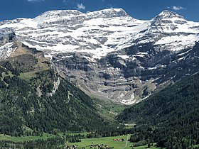
The 2,000-metre-high north side of the Diablerets
|
|
| Highest point | |
| Peak | Sommet des Diablerets |
| Elevation | 3,210 m (10,530 ft) |
| Prominence | 968 m (3,176 ft) |
| Isolation | 14.3 km (8.9 mi) |
| Parent peak | Finsteraarhorn |
| Listing | Canton high point |
| Coordinates | 46°18′14″N 7°11′21″E / 46.30389°N 7.18917°ECoordinates: 46°18′14″N 7°11′21″E / 46.30389°N 7.18917°E |
| Naming | |
| Translation | The Abode of Devils (French) |
| Geography | |
| Country | Switzerland |
| Cantons | Vaud, Valais and Bern |
| Parent range | Bernese Alps |
| Topo map | Swiss Federal Office of Topography swisstopo |
| Geology | |
| Mountain type | Limestone |
The Diablerets (French: Les Diablerets; lit. "the abode of devils") are a huge ice-covered mountain massif of the Alps, culminating at the Sommet des Diablerets (VD, VS) at 3,210 metres (10,530 ft) above sea level and straddling the border between the Swiss cantons of Vaud (VD) and Valais (VS). The northeastern part of the massif streches also into the canton of Bern (BE).
The Diablerets massif, which consists of several peaks, extends for about 10 kilometres near the western extremity of the Bernese Alps, between the two deep passes, the Cheville Pass (2,038 m (6,686 ft)) right below the main summit to the south, and the Sanetsch/Sénin Pass (2,252 m (7,388 ft)) to the east. The mountain is covered by two distinct glaciers, the largest being the Tsanfleuron Glacier and the highest being the Diablerets Glacier.
The main summit (officially referred to as Sommet des Diablerets) is the highest point in the canton of Vaud. In the latter canton, the mountain has given its name to the nearby village and resort of Les Diablerets, which lies on the north side of the massif. On the south side (Valais) the mountain overlooks the hamlet and valley of Derborence.
Along with the Muverans, the Wildhorn and the Wildstrubel, the Diablerets are one of the four distinct and glaciated massifs of the Bernese Alps that lie between the Rhone elbow and the Gemmi Pass. The main section of the mountain, between the cantons of Vaud and Valais, is part of the Rhone basin, through the rivers Grande Eau (north) and Lizerne (south). The easternmost part of the massif, that lies in the canton of Bern, is part of the Rhine basin, through the river Sarine (French, Saane in German). The Oldehore (Swiss German, Germanized: Oldenhorn) is the tripoint of the three cantons of Vaud, Valais and Bern, and several of the peaks have a German as well as a French name.
...
Wikipedia

