Devils Lake (North Dakota)
| Devils Lake | |
|---|---|

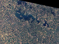
View from space (March 2009)
|
|
| Location | Ramsey / Benson counties, North Dakota, USA |
| Coordinates | 48°2′5″N 98°56′39″W / 48.03472°N 98.94417°WCoordinates: 48°2′5″N 98°56′39″W / 48.03472°N 98.94417°W |
| Lake type |
Endorheic basin Potentially an open lake owing to climate change |
| Catchment area | 3,810 sq mi (9,900 km2) |
| Basin countries | United States |
| Max. depth | more than 54.3 feet (16.6 m) |
| Surface elevation | 1,454.20 ft (443.24 m) |
| Settlements | Devils Lake, Minnewaukan |
Devils Lake is a lake in the U.S. state of North Dakota. It is the largest natural body of water and the second-largest body of water in North Dakota after Lake Sakakawea. It can reach a level of 1,458 ft (444 m) before naturally flowing into the Sheyenne River via the Tolna Coulee. On June 27, 2011, it reached an unofficial historical high elevation of 1,454.3 ft (443.3 m).
The city of Devils Lake, North Dakota, takes its name from the lake. The Spirit Lake Reservation is located on the lake's southern shores. The name "Devils Lake" is an approximate translation of its Lakota name, Ble Waka Sica ("blay wah-kahn shee-chah"; literally: "Lake of the Spirits"). Its Arikara name is "čiwahaahwaarúxtiʾ [čiWAhaahwaarúxti’]".
Devils Lake is located in Ramsey County and Benson County in northeastern North Dakota. The Spirit Lake Tribe occupies most of the southern shore and has been adversely affected by flooding since the 1990s.
Devils Lake is the endorheic, or closed, lake of a drainage basin of some 3,800 sq mi (9,800 km2), the Devils Lake Basin. The lake collects around 86 percent of the basin's water runoff. Above an elevation of 1,447 ft (441 m) AMSL, the lake spills into neighboring Stump Lake. At 1,458 ft (444 m), the combined lake flows naturally into the Sheyenne River, though the lake has not reached this level in approximately 1000 years. The Sheyenne River is a tributary to the Red River, which flows into Canada, with eventual exit into the Hudson Bay. Dike protection is set at 1,454 ft (443 m).
...
Wikipedia
