Dermott, Arkansas
| Dermott, Arkansas | |
|---|---|
| City | |

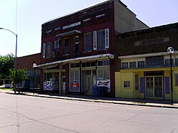
Downtown Dermott
|
|
 Location in Chicot County and the state of Arkansas |
|
| Coordinates: 33°31′43″N 91°26′16″W / 33.52861°N 91.43778°WCoordinates: 33°31′43″N 91°26′16″W / 33.52861°N 91.43778°W | |
| Country | United States |
| State | Arkansas |
| County | Chicot |
| Area | |
| • Total | 3.6 sq mi (9.4 km2) |
| • Land | 3.6 sq mi (9.2 km2) |
| • Water | 0.08 sq mi (0.2 km2) |
| Elevation | 141 ft (43 m) |
| Population (2010) | |
| • Total | 2,889 |
| • Density | 811/sq mi (313.2/km2) |
| Time zone | Central (CST) (UTC-6) |
| • Summer (DST) | CDT (UTC-5) |
| ZIP code | 71638 |
| Area code(s) | 870 |
| FIPS code | 05-18520 |
| GNIS feature ID | 0057646 |
Dermott is a city in Chicot County, Arkansas, United States. The population was 2,889 at the 2010 census. Dermott was incorporated in 1890.
Dermott was home to the Dermott Crawfish Festival.
Dermott is located in the northwest corner of Chicot County at 33°31′43″N 91°26′16″W / 33.52861°N 91.43778°W (33.528712, -91.437657).Bayou Bartholomew, a tributary of the Ouachita River, touches the southwest corner of the city. U.S. Route 165 passes southeast of the city center, leading north 9 miles (14 km) to McGehee and south 15 miles (24 km) to Montrose. Arkansas Highway 35 passes through the center of Dermott and leads northwest 23 miles (37 km) to Monticello.
According to the United States Census Bureau, Dermott has a total area of 3.6 square miles (9.4 km2), of which 3.6 square miles (9.2 km2) is land and 0.08 square miles (0.2 km2), or 1.97%, is water.
The climate in this area is characterized by hot, humid summers and generally mild to cool winters. According to the Köppen Climate Classification system, Dermott has a humid subtropical climate, abbreviated "Cfa" on climate maps.
As of the 2010 United States Census, there were 2,889 people residing in the city. 77.8% were African American, 20.2% White, 0.1% Native American, 0.7% Asian, 0.1% from some other race and 1.0% from two or more races. 1.0% were Hispanic or Latino of any race.
...
Wikipedia
