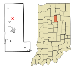
Denver, Indiana
| Denver, Indiana | |
|---|---|
| Town | |
| Town of Denver | |
 Location in the state of Indiana |
|
| Coordinates: 40°51′55″N 86°4′40″W / 40.86528°N 86.07778°WCoordinates: 40°51′55″N 86°4′40″W / 40.86528°N 86.07778°W | |
| Country | United States |
| State | Indiana |
| County | Miami |
| Township | Jefferson |
| Area | |
| • Total | 0.23 sq mi (0.60 km2) |
| • Land | 0.23 sq mi (0.60 km2) |
| • Water | 0 sq mi (0 km2) |
| Elevation | 709 ft (216 m) |
| Population (2010) | |
| • Total | 482 |
| • Estimate (2016) | 471 |
| • Density | 2,096/sq mi (809.2/km2) |
| Time zone | Eastern (EST) (UTC-5) |
| • Summer (DST) | EST (UTC-5) |
| ZIP code | 46926 |
| Area code(s) | 765 |
| FIPS code | 18-17776 |
| GNIS feature ID | 433483 |
Denver is a town in Jefferson Township, Miami County, in the U.S. state of Indiana. The population was 482 at the 2010 census.
Denver is served by North Miami Schools.
Denver was laid out in 1872 when the Eel River Railroad was extended to that point. The town was named after Denver, Colorado. The post office at Denver has been in operation since 1869.
Denver is located at 40°51′55″N 86°4′40″W / 40.86528°N 86.07778°W (40.865277, -86.077746).
According to the 2010 census, Denver has a total area of 3.61 square miles (9.35 km2), all land.
As of the census of 2010, there were 482 people, 177 households, and 133 families residing in the town. The population density was 2,095.7 inhabitants per square mile (809.2/km2). There were 194 housing units at an average density of 843.5 per square mile (325.7/km2). The racial makeup of the town was 98.8% White, 0.2% African American, 0.6% Native American, and 0.4% from two or more races. Hispanic or Latino of any race were 1.2% of the population.
...
Wikipedia
