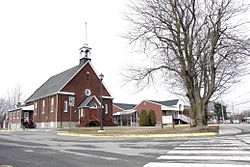
Delson, Quebec
| Delson | ||
|---|---|---|
| City | ||
 |
||
|
||
 Location within Roussillon RCM |
||
| Location in southern Quebec | ||
| Coordinates: 45°22′N 73°33′W / 45.37°N 73.55°WCoordinates: 45°22′N 73°33′W / 45.37°N 73.55°W | ||
| Country |
|
|
| Province |
|
|
| Region | Montérégie | |
| RCM | Roussillon | |
| Constituted | January 4, 1918 | |
| Government | ||
| • Mayor | Christian Ouellette | |
| • Federal riding | La Prairie | |
| • Prov. riding | La Prairie | |
| Area | ||
| • Total | 7.70 km2 (2.97 sq mi) | |
| • Land | 7.59 km2 (2.93 sq mi) | |
| Population (2011) | ||
| • Total | 7,462 | |
| • Density | 982.6/km2 (2,545/sq mi) | |
| • Pop 2006-2011 |
|
|
| • Dwellings | 2,911 | |
| Time zone | EST (UTC−5) | |
| • Summer (DST) | EDT (UTC−4) | |
| Postal code(s) | J5B | |
| Area code(s) | 450 and 579 | |
| Highways |
|
|
| Website | www |
|
Delson is an off-island suburb (South shore) of Montreal, Quebec, Canada. It is situated 8 mi/13 km SSE of Montreal within the regional county municipality of Roussillion in the administrative region of Montérégie. The population as of the Canada 2011 Census was 7,462.
On its small territory, Delson is crossed by Route 132 and the Turtle River (rivière de la Tortue). The city owns a portion of the Champlain industrial park as well as the Delson commuter train station with service to and from Montreal on the AMT's Candiac Line.
The origin of the name Delson comes from the Delaware and Hudson Railway, now a subsidiary of the Canadian Pacific Railway, which runs through the town. The Canadian Railway Museum (Exporail) occupies a large tract between Delson and Saint-Constant.
Delson was founded in 1918 as a village municipality before obtaining its status of a city 21 February 1957. The village of Delson was created from three parishes: St Andrews (1924) of the United Church and St David (1938) of the Anglican as well as Sainte-Thérèse-de-l'Enfant-Jésus (1932) of the Catholic faith.
...
Wikipedia


