Dellroy, Ohio
| Dellroy, Ohio | |
|---|---|
| Village | |

Dellroy is decorated each Halloween.
|
|
 Location of Dellroy, Ohio |
|
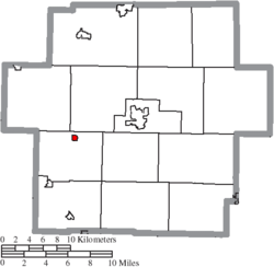
 Location of Dellroy in Carroll County |
|
| Coordinates: 40°33′19″N 81°11′58″W / 40.55528°N 81.19944°WCoordinates: 40°33′19″N 81°11′58″W / 40.55528°N 81.19944°W | |
| Country | United States |
| State | Ohio |
| County | Carroll |
| Township | Monroe |
| Area | |
| • Total | 0.21 sq mi (0.54 km2) |
| • Land | 0.18 sq mi (0.47 km2) |
| • Water | 0.03 sq mi (0.08 km2) |
| Elevation | 958 ft (292 m) |
| Population (2010) | |
| • Total | 356 |
| • Estimate (2012) | 354 |
| • Density | 1,977.8/sq mi (763.6/km2) |
| Time zone | Eastern (EST) (UTC-5) |
| • Summer (DST) | Eastern (EDT) (UTC-4) |
| ZIP code | 44620 |
| Area code(s) | 330 |
| FIPS code | 39-21560 |
| GNIS feature ID | 1064525 |
Dellroy is a village in Carroll County, Ohio, United States. The population was 356 at the 2010 census. It is part of the Canton–Massillon Metropolitan Statistical Area.
The village was established in 1849 as "Cannonsburg." It was renamed circa 1878 to Dellroy. The origin of the name "Dellroy" is disputed.
Dellroy is located at 40°33′19″N 81°11′58″W / 40.55528°N 81.19944°W (40.555227, -81.199436).
According to the United States Census Bureau, the village has a total area of 0.21 square miles (0.54 km2), of which 0.18 square miles (0.47 km2) is land and 0.03 square miles (0.08 km2) is water.
Dellroy lies at the junction of State Routes 39 and 542.
As of the census of 2010, there were 356 people, 134 households, and 94 families residing in the village. The population density was 1,977.8 inhabitants per square mile (763.6/km2). There were 148 housing units at an average density of 822.2 per square mile (317.5/km2). The racial makeup of the village was 97.2% White, 0.6% African American, 1.4% Native American, and 0.8% from two or more races. Hispanic or Latino of any race were 0.6% of the population.
...
Wikipedia
