Deline, Northwest Territories
|
Deline Délı̨ne |
|
|---|---|
| Charter Community | |
 |
|
 Great Bear Lake, NWT, Canada |
|
| Location of Deline within Canada | |
| Coordinates: 65°11′12″N 123°25′18″W / 65.18667°N 123.42167°WCoordinates: 65°11′12″N 123°25′18″W / 65.18667°N 123.42167°W | |
| Country | Canada |
| Territory | Northwest Territories |
| Region | Sahtu Region |
| Constituency | Sahtu |
| Census division | Region 2 |
| Charter Community | 1 April 1993 |
| Government | |
| • Chief | Leonard Kenny |
| • Senior Administrative Officer | Rosy Ann Tutcho |
| • MLA | Norman Yakeleya |
| Area | |
| • Land | 79.44 km2 (30.67 sq mi) |
| Elevation | 214 m (702 ft) |
| Population (2011) | |
| • Total | 472 |
| • Density | 5.9/km2 (15/sq mi) |
| Time zone | Mountain (MST) (UTC-7) |
| • Summer (DST) | MDT (UTC-6) |
| Canadian Postal code | X0E 0G0 |
| Area code(s) | 867 |
| Telephone exchange | 589 |
| - Living cost | 172.5 |
| - Food price index | 172.1 |
| Website | www.deline.ca |
| Sources: Department of Municipal and Community Affairs, Prince of Wales Northern Heritage Centre, Canada Flight Supplement ^A 2009 figure based on Edmonton = 100 ^B 2012 figure based on Yellowknife = 100 |
|
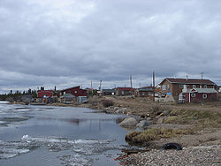
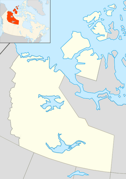
The Charter Community of Délįne (pronounced "day-li-neh") is located in the Sahtu Region of the Northwest Territories, Canada, on the western shore of Great Bear Lake and is 544 km (338 mi) northwest of Yellowknife. Délįne means "where the waters flow", a reference to the headwaters of the Great Bear River, Sahtúdé.
According to early records, a trading post was established in this general area as early as 1799 by the North West Company, but it did not last very many years. In 1825, Peter Warren Dease of the Hudson's Bay Company (HBC) erected an outpost here as the staging area and winter quarters for Sir John Franklin's second Arctic expedition (1825–1827). It became known as Fort Franklin. Sir John Franklin's diary records that his men played ice sports very similar to what we now call hockey. As such, the modern-day town promotes itself as one of the birthplaces of the sport of ice hockey.
The HBC returned and established a post called Fort Norman a short distance west, and across the lake narrows, from John Franklin's original post, between 1863 and 1869, and then relocated Fort Norman to its current location at the confluence of the Mackenzie and Bear Rivers (now Tulita).
Fort Franklin as a modern era trading post of the HBC was not established until later in the 19th century. It was constructed at one of the most productive Dene fisheries in the Mackenzie River drainage basin and was for the benefit of the Dene people who lived in near isolation along the shores of Great Bear Lake.
The area became prominent when pitchblende was discovered at the Eldorado Mine, some 250 km (160 mi) away, on the eastern shore, at Port Radium. During World War II, the Canadian Government took over the mine and began to produce uranium for the then-secret American nuclear bomb project. Uranium product was transported from Port Radium by barge across Great Bear Lake where a portage network was established along the Bear River, across the bay from Fort Franklin, where many of the Dene men found work. As the risks associated with radioactive materials were not well communicated, it is believed that many of the Dene were exposed to dangerous amounts of radiation, which Déline residents believe resulted in the development of cancer and led to premature deaths.
...
Wikipedia

