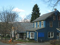
Delaware Water Gap, Pennsylvania
| Borough of Delaware Water Gap | |
| Settlement | |
|
Delaware Water Gap, Pennsylvania
|
|
| Country | United States |
|---|---|
| State | Pennsylvania |
| County | Monroe |
| Elevation | 400 ft (121.9 m) |
| Coordinates | 40°58′55″N 75°08′33″W / 40.98194°N 75.14250°WCoordinates: 40°58′55″N 75°08′33″W / 40.98194°N 75.14250°W |
| Area | 1.7 sq mi (4.4 km2) |
| - land | 1.7 sq mi (4 km2) |
| - water | 0.0 sq mi (0 km2), 0% |
| Population | 746 (2010) |
| Density | 427.4/sq mi (165.0/km2) |
| Mayor | Robert Gallagher (D) |
| Timezone | EST (UTC-5) |
| - summer (DST) | EDT (UTC-4) |
| ZIP Code | 18327 |
| Area code | 570 |
|
Location of Delaware Water Gap in Monroe County
|
|
Delaware Water Gap is a borough in Monroe County, Pennsylvania, United States. It is located adjacent to the Delaware Water Gap, the pass through which the Lackawanna Corridor and Interstate 80 run across the Pennsylvania-New Jersey border along the Delaware River.
The population of Delaware Water Gap was 746 at the 2010 census.
The Delaware Water Gap (Delaware, Lackawanna and Western Railroad station) was added to the National Register of Historic Places in 2002.
Delaware Water Gap is located at 40°58′55″N 75°8′33″W / 40.98194°N 75.14250°W (40.982028, -75.142624).
According to the United States Census Bureau, the borough has a total area of 1.7 square miles (4.4 km2), all of it land.
As of the 2010 United States Census, there were 746 people residing in the borough. The racial makeup of the borough was 81.4% White, 6.3% Black, 0.1% Native American, 3.9% Asian, 0.1% Pacific Islander and 0.9% from two or more races. 7.2% were Hispanic or Latino of any race.
...
Wikipedia


