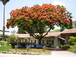
Degania Alef
| Degania Alef | |
|---|---|

The original Zionist kibbutz settlement
|
|
| Coordinates: 32°42′29″N 35°34′29″E / 32.70806°N 35.57472°ECoordinates: 32°42′29″N 35°34′29″E / 32.70806°N 35.57472°E | |
| District | Northern |
| Council | Emek HaYarden |
| Affiliation | Kibbutz Movement |
| Founded | 1910, after first beginnings in 1909 |
| Founded by | Jewish pioneers |
| Population (2015) | 534 |
| Website | www.degania.org.il |
Degania Alef (Hebrew: דְּגַנְיָה א', D'ganya Alef) is a kibbutz in northern Israel. It falls under the jurisdiction of the Emek HaYarden Regional Council. Degania was Israel's first kvutza, a communal settlement smaller than a kibbutz. It was established in 1909 in Ottoman Palestine. Degania Alef and its neighbour Degania Bet both lie between the southern shore of the Sea of Galilee and the Jordan River. In 2015 it had a population of 534.
Degania means "cornflower" and is derived from dagan, meaning "grain". After the first phase at Umm Junieh, the group and its settlement was simply called Degania, Alef being added only after the establishment of the associated kibbutzim of Degania Bet and Gimel in 1920. Alef, Bet and Gimel are the first letters of the Hebrew alphabet and carry the numerical values 1, 2 and 3.
According to the 1881 Survey of Western Palestine, Umm Junieh was possibly the place called Union, or Homonœa, by Josephus (Vita, 54).
The Muslim village called Umm Junieh is mentioned during the Late Ottoman period (late 19th century) at the site from which the first Jewish settlers would start establishing their community in 1909-1910. A map from Napoleon's invasion of 1799 by Pierre Jacotin showed the place as ruined.Umm Junieh was just by the ancient bridge Jisr es Sidd, which was also marked as ruined by Jacotin.
...
Wikipedia

