Deer Park (Toronto)
| Deer Park | |
|---|---|
| Neighbourhood | |

Christ Church in Yonge St Gore
|
|
 Location of Deer Park within Toronto |
|
| Country |
|
| Province |
|
| City |
|
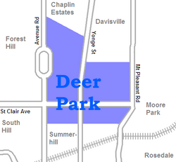
Deer Park is a neighbourhood in Toronto, Ontario, Canada, centred on the intersection of Yonge Street and St. Clair Avenue; its boundaries are the Vale of Avoca section of Rosedale ravine in the east, Farnham Avenue and Jackes Avenue in the south, Avenue Road and Oriole Parkway in the west, the Belt Line trail in the north on the west side of Yonge Street, and Glen Elm Avenue in the north on the east side of Yonge Street. For the purposes of social policy analysis & research, the City of Toronto’s Social Development & Administration division includes Deer Park within the City of Toronto's official "Rosedale-Moore Park" and "Yonge-St.Clair" neighbourhood profiles. The neighbourhood is in Ward 22, represented by Councillor Josh Matlow at Toronto city council.
The commercial area along the main streets is known simply as Yonge and St. Clair. Marked by a cluster of office buildings, the area also includes a number of restaurants, shops and services, and the St. Clair subway station, the terminus for the 512 St. Clair street car.
The name dates from 1837, when the Heath family purchased 40 acres (162,000 m²) of land on the northwest corner of Yonge and St. Clair (then the Third Concession Road) and named it Deer Park. By the 1850s the neighbourhood included a racetrack, a school, and a hotel at which patrons could feed deer which roamed the Heaths' property. The Heath property was subdivided in 1846 and was entirely sold off by 1874.
In 1891 Upper Canada College moved from its urban location to the then still rural Deer Park area, establishing a large campus that remains in the same location today, interrupting Avenue Road north of St. Clair Avenue.
In 1931 De La Salle College (Toronto) moved from its downtown location to an estate named 'Oaklands' originally purchased and built upon by Senator John Macdonald in 1858. Oaklands forms part of the southern boundary of Deer Park, running eastward along the escarpment from Avenue Road.
...
Wikipedia
