Death Valley Junction, California
| Death Valley Junction | |
|---|---|
| Unincorporated community | |

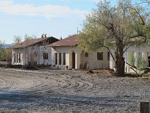
Old buildings in the Historic District
|
|
| Location in California | |
| Coordinates: 36°18′08″N 116°24′49″W / 36.30222°N 116.41361°WCoordinates: 36°18′08″N 116°24′49″W / 36.30222°N 116.41361°W | |
| Country | United States |
| State | California |
| County | Inyo County |
| Elevation | 2,041 ft (622 m) |
| FIPS code | 06-18212 |
| GNIS feature ID | 1656477 |
|
Death Valley Junction Historic District
|
|

|
|
| Location | CA 127 and CA 190, Death Valley Junction, California |
| Built | 1923 |
| Architect | Alexander H. McCulloch |
| Architectural style | Mission/Spanish Revival |
| NRHP Reference # | 80000802 |
| Added to NRHP | December 10, 1980 |
Death Valley Junction (formerly, Amargosa and Death Valley) is a tiny Mojave Desert community in unincorporated community Inyo County, California, at the intersection of SR 190 and SR 127, just east of Death Valley National Park. The zip code is 92328, the elevation is 2,041 ft (622 m), and the population fewer than 20. The city limits sign reports a population of 4. The U.S. Geological Survey lists a historic variant name of Amargosa for the community which is shown as the primary name on an official State of Nevada map from 1971. The default format for wired phone numbers in this community is (760) 852-xxxx.
Death Valley Junction is home to the Amargosa Opera House and Hotel, where resident Marta Becket staged dance and mime shows from the late 1960s until her last show in February 2012. The hotel is still operating next to the opera house, but beyond these maintained areas, the town is in a state of disrepair. There are no gas stations, and only one restaurant. The single restaurant, T&T Cafe, is part of the Amargosa Opera House and Hotel, but is not run by the hotel staff.
The community's location, 27 miles (43 km) east-southeast of Furnace Creek Inn, on the east side of Death Valley is south of Nevada's Amargosa Valley and near Ash Meadows National Wildlife Refuge. East/South East, 27 miles, is Pahrump, Nevada. South on SR127 is the town of Shoshone, California. The closest straight-line distance to the Nevada state line is roughly five miles northeast.
...
Wikipedia


