Davis Junction, Illinois
| Davis Junction | |
|---|---|
| Village | |

Sign leading into the west side of the village
|
|
| Location within Ogle County | |
| Coordinates: 42°06′07″N 89°05′37″W / 42.10194°N 89.09361°WCoordinates: 42°06′07″N 89°05′37″W / 42.10194°N 89.09361°W | |
| Country | United States |
| State | Illinois |
| County | Ogle |
| Township | Scott |
| Government | |
| • Village President | Ken Diehl |
| Area | |
| • Total | 4.24 sq mi (11.0 km2) |
| • Land | 4.24 sq mi (11.0 km2) |
| • Water | 0.00 sq mi (0.0 km2) |
| Elevation | 791 ft (241 m) |
| Population (2010) | |
| • Total | 2,373 |
| • Density | 560/sq mi (220/km2) |
| Postal code | 61020 |
| Area code(s) | 815 |
| Website | www |
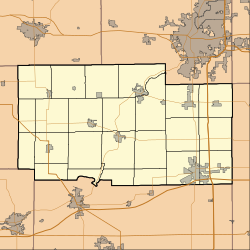
Davis Junction is a village in Ogle County, Illinois, United States. The population was 2,373 at the 2010 census, up from 491 in 2000. Named for Jeremiah Davis, it is located where the Illinois Railway Rockford Line and the Canadian Pacific Chicago Subdivision intersect along Illinois Route 72.
Jeremiah Davis laid out Davis Junction in the 1870s, and named the settlement for himself. A post office has been in operation at Davis Junction since 1875.
Davis Junction is located at 42°6′7″N 89°5′37″W / 42.10194°N 89.09361°W (42.101928, -89.093696).
According to the 2010 census, Davis Junction has a total area of 4.24 square miles (10.98 km2), all land.
As of the census of 2000, there were 491 people, 165 households, and 132 families residing in Davis Junction. The population density was 129.6 people per square mile (50.0/km²). There were 172 housing units at an average density of 45.4 per square mile (17.5/km²). The racial makeup of the village was 98.37% White, 0.41% Asian, 0.41% from other races, and 0.81% from two or more races. Hispanic or Latino of any race were 1.02% of the population.
...
Wikipedia


