Davao region
|
Davao Region Region XI Southern Mindanao (formerly) |
|
|---|---|
| Region | |

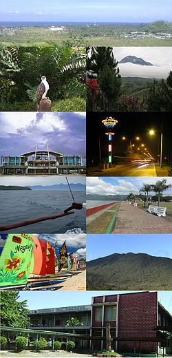
From top, left to right:
|
|
 Location in the Philippines |
|
| Coordinates: 7°05′N 125°35′E / 7.08°N 125.58°ECoordinates: 7°05′N 125°35′E / 7.08°N 125.58°E | |
| Country | Philippines |
| Island group | Mindanao |
| Regional center | Davao City |
| Area | |
| • Total | 20,357.42 km2 (7,860.04 sq mi) |
| Population (2015 census) | |
| • Total | 4,893,318 |
| • Density | 240/km2 (620/sq mi) |
| Time zone | PST (UTC+8) |
| ISO 3166 code | PH-11 |
| Provinces | |
| Cities | |
| Municipalities | 43 |
| Barangays | 1162 |
| Cong. districts | 11 |
| Languages | |
Davao Region, formerly called Southern Mindanao (Cebuano: Habagatang Mindanao; Filipino: Timog Mindanao), is an administrative region in the Philippines, designated as Region XI. It is situated at the southeastern portion of Mindanao, comprising five provinces: Compostela Valley, Davao del Norte, Davao del Sur, Davao Oriental and Davao Occidental, the newly created province.
The region encloses the Davao Gulf, and its regional center is Davao City. Davao is the Hispanicized pronunciation of daba-daba, the Bagobo word for "fire" (the Cebuano translation is kalayo).
Many historians believe that the name Davao is the mixture of the three names that three different tribes, the earliest settlers in the region, had for the Davao River. The Manobos, an aboriginal tribe, referred to the Davao River as Davohoho. Another tribe, the Bagobos, referred to the river as Davohaha, which means "fire", while another tribe, the Guiangan tribe, called the river as Duhwow.
The history of the region dates back to the times when various tribes occupied the region. It is believed that the Manobos, Mandayas and the Bagobos occupied the area. These are the same tribes that created the small settlements and communities that eventually became Mindanao.
...
Wikipedia
