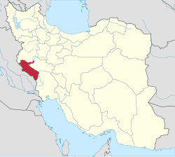
Darreh Shahr County
|
Darreh Shahr County شهرستان درهشهر |
|
|---|---|
| County | |
 Counties of Ilam Province |
|
 Location of Ilam Province in Iran |
|
| Coordinates: 33°08′N 47°22′E / 33.133°N 47.367°ECoordinates: 33°08′N 47°22′E / 33.133°N 47.367°E | |
| Country |
|
| Province | Ilam Province |
| Capital | Darreh Shahr |
| Bakhsh (Districts) | Central District, Badreh District, Majin District |
| Population (2006) | |
| • Total | 56,346 |
| Time zone | IRST (UTC+3:30) |
| • Summer (DST) | IRDT (UTC+4:30) |
| Website | City's Gubernatorial Portal |
| Darreh Shahr County can be found at GEOnet Names Server, at this link, by opening the Advanced Search box, entering "9205932" in the "Unique Feature Id" form, and clicking on "Search Database". | |
Darreh Shahr County (Persian: شهرستان درهشهر) is a county in Ilam Province in Iran. The capital of the county is Darreh Shahr. At the 2006 census, the county's population was 56,346, in 11,487 families. The county is subdivided into three districts: the Central District, Badreh District, and Majin District. The county has two cities: Darreh Shahr and Badreh.
People speak Laki and Luri mostly but all of the residents of Badreh speak Kurdish.
The remains of the Sassanide city of Dareh Shahr is situated between new Dareh Shahr and the Bahman Abad Village. Presently, some vestiges of arches, ceilings, dome-shaped ceilings as well as indications of passages, alleys and urban connection network are visible in the texture of the ruins.
There is a fire-temple in the city of Dareh Shahr which is a four-arched building which is locally called Taaq. Originally the building was constructed by rubble stone and gypsum, and has recently been repaired.
This Sassanide bridge has been constructed in the confluence of the Seimareh and Kashkan Rivers. Although it has been repaired several times during the past, it is almost in a ruined state now.
There are many crevices and caves one of them is known as the Kulkani Cave. The entrance of the cave is 30 meters long and there is a small pond built of stone and Sarouj (plaster of lime and ashes or sands). In addition, there are 12 other caves similar to the dwellings of pre-historic man. Some vestiges like earthenware pieces and other objects belonging to the mid 1st millennium BC. have been discovered in this cave.
Located 6 kilometers southeast of Dareh Shahr, the ruins of this fort can be seen in the entrance of the village with the same name with 150 years of antiquity. Construction materials indicate that it belongs to the Qajar period. The walls of the fort are delicately made of stone and gypsum. There is also the remains of a water mill.
...
Wikipedia
