Daraga, Albay
| Daraga | |
|---|---|
| Municipality | |

Daraga Church with Mayon Volcano in the background
|
|
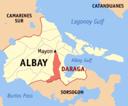
 Location within Albay province |
|
| Location within the Philippines | |
| Coordinates: 13°09′43″N 123°41′38″E / 13.1619°N 123.6939°ECoordinates: 13°09′43″N 123°41′38″E / 13.1619°N 123.6939°E | |
| Country | Philippines |
| Region | Bicol Region (Region V) |
| Province | Albay |
| District | 2nd district |
| Founded | June 12, 1772 |
| Barangays | 54 (see Barangays) |
| Government | |
| • Type | Sangguniang Bayan |
| • Mayor | Gerry R. Jaucian |
| • Vice Mayor | Carlwyn "Awin" G. Baldo |
| Area | |
| • Total | 118.64 km2 (45.81 sq mi) |
| Population (2015 census) | |
| • Total | 126,595 |
| • Density | 1,100/km2 (2,800/sq mi) |
| • Voter (2016) | 66,648 |
| Demonym(s) | Daragueño |
| Time zone | PST (UTC+8) |
| ZIP code | 4501 |
| IDD : area code | +63 (0)52 |
| Income class | 1st class |
| PSGC | 050503000 |
| Website | www |
Daraga, officially the Municipality of Daraga (Central Bikol: Banwaan kan Daraga; Filipino: Bayan ng Daraga), is a municipality in the province of Albay in the Bicol Region (Region V) of the Philippines. The population was 126,595 at the 2015 census. In the 2016 electoral roll, it had 66,648 registered voters.
The town is home to the landmark Cagsawa Ruins.
The word daraga historically referred to a "maiden", and is the modern term for an "unmarried woman" in many of the Bikol languages. The original settlement of Daraga dates back to 12th century, but has changed location repeatedly due to the constant threats posed by Mayon Volcano. The town was previously named Budiao, Cagsawa, and Locsin.
Daraga is located at 13°09′43″N 123°41′38″E / 13.1619°N 123.6939°E, in the south-west portion of Albay province, along the Maharlika Highway, making it accessible from Manila, the Visayas, and the other municipalities of eastern Bicol Peninsula. It is roughly "boot-shaped", with the "tall" part ranging 13.05–13.25° north latitude and 123.66–123.73° east longitude and the "wide" part ranging 13.02–13.09° north latitude and 123.56–123.71° east longitude. It is bounded on the north and east by Legazpi City, south by Sorsogon (particularly the municipality of Pilar), and west by Camalig and Jovellar.
...
Wikipedia

