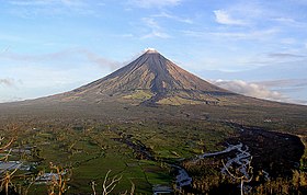
Mayon Volcano
| Mayon | |
|---|---|
| Bulkang Mayon (Central Bikol) | |

|
|
| Highest point | |
| Elevation | 2,463 m (8,081 ft) |
| Prominence | 2,447 m (8,028 ft) |
| Listing | |
| Coordinates | 13°15′24″N 123°41′6″E / 13.25667°N 123.68500°ECoordinates: 13°15′24″N 123°41′6″E / 13.25667°N 123.68500°E |
| Geography | |
| Location | Luzon |
| Country | Philippines |
| Region | Bicol Region |
| Province | Albay |
| Cities and municipalities |
|
| Geology | |
| Age of rock | more than 20 million years old |
| Mountain type | Stratovolcano |
| Last eruption | September 18, 2014 |
| Climbing | |
| First ascent | Scotsmen Paton & Stewart (1858) |
Mayon (Central Bikol: Bulkan Mayon, Filipino: Bulkang Mayon), also known as Mount Mayon or Mayon Volcano, is an active stratovolcano in the province of Albay in Bicol Region, on the island of Luzon in the Philippines. Renowned as the "perfect cone" because of its symmetric conical shape, the volcano and its surrounding landscape was declared a national park on July 20, 1938, the first in the nation. It was reclassified a Natural Park and renamed Mayon Volcano Natural Park in the year 2000. Local folklore refers to the volcano being named after the legendary princess-heroine Daragang Magayon (English: Beautiful Lady).
Mayon is the main landmark and highest point of the province of Albay and the whole Bicol Region in the Philippines, rising 2,462 metres (8,077 ft) from the shores of the Albay Gulf about 10 kilometres (6.2 mi) away. The volcano is geographically shared by the eight cities and municipalities of Legazpi, Daraga, Camalig, Guinobatan, Ligao, Tabaco, Malilipot and Santo Domingo (clockwise from Legazpi), which divide the cone like slices of a pie when viewed from above.
...
Wikipedia

