Damxung
|
Damxung County 当雄县 • འདམ་གཞུང་རྫོང་། |
|
|---|---|
| County | |

|
|
 Location of Damxung County within Tibet |
|
| Coordinates: 30°31′04″N 90°45′46″E / 30.51778°N 90.76278°ECoordinates: 30°31′04″N 90°45′46″E / 30.51778°N 90.76278°E | |
| Country | China |
| Province | Tibet |
| Prefecture | Lhasa |
| Capital | Damquka |
| Area | |
| • Total | 10,036 km2 (3,875 sq mi) |
| Population (1999) | |
| • Total | 38,473 |
| Time zone | China Standard (UTC+8) |
| Website | http://www.dangxiong.gov.cn |
| Damxung County | |||||||
| Chinese name | |||||||
|---|---|---|---|---|---|---|---|
| Simplified Chinese | 当雄县 | ||||||
| Traditional Chinese | 當雄縣 | ||||||
|
|||||||
| Tibetan name | |||||||
| Tibetan | འདམ་གཞུང་རྫོང་། | ||||||
|
|||||||
| Transcriptions | |
|---|---|
| Standard Mandarin | |
| Hanyu Pinyin | Dāngxióng Xiàn |
| Transcriptions | |
|---|---|
| Wylie | 'dam gzhung rdzong |
| Tibetan Pinyin | Damxung Zong |
Damxung is a county in the Lhasa prefecture-level city to the north of the main center of Lhasa in the Tibet Autonomous Region of the People's Republic of China. Its administrative seat is Damquka. The terrain is rugged, including the western Nyenchen Tanglha Mountains, with their highest peak rising to 7,111 metres (23,330 ft). As of 2013 the population was 40,000, with most of the people engaged in animal husbandry.
Damxung means "select pasture" in the Tibetan language. The county has an area of 10,036 square kilometres (3,875 sq mi), with rugged topography. Damxung is long and narrow, measuring 185 kilometres (115 mi) from the northeast to southwest extremes, and at most 65 km across (40 mi). It is tectonically active. On 6 October 2008 an earthquake measuring 6.6 on the Richter magnitude scale was reported. In November 2010 a moderate quake in Damxung at 5.2 on the Richter scale shook office windows in Lhasa. There were no casualties, but houses were damaged.
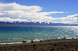
In the extreme northeast of the county, Namtso lake has an area of 1,920 square kilometres (740 sq mi), of which 45% lies in Damxung county. Namtso is one of the great lakes of the Tibetan plateau. The Nyenchen Tanglha (or Nyainqentanglha) mountains extend along the northwest of the county. Mount Nyenchen Tanglha is the highest peak in the region, at 7,111 metres (23,330 ft). The Nyainqêntanglha mountains define the watershed between northern and southern Tibet. A valley with elevation of about 4,200 metres (13,800 ft) runs parallel to the mountains to their southeast, sloping from northwest to southeast. 30% of the county's total area is in the prairie of this valley.
Damxung is cold and dry in the winter, cool and wet in summer, with very variable weather. The average annual temperature is 1.3 °C (34.3 °F), with only 62 frost-free days. The land is frozen from the start of November to the following March. Pasture has 90–120 days for growth. Average annual precipitation is 481 millimetres (18.9 in).
Damxung County was established in 1959, and is divided into two towns and six townships. The seat of government is in Dangquka (当曲卡镇).
...
Wikipedia
