Lhasa (prefecture-level city)
|
Lhasa 拉萨市 • ལྷ་ས་གྲོང་ཁྱེར། |
|
|---|---|
| Prefecture-level city | |

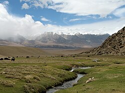
Yangpachen Valley, Damxung County
|
|
 Location within China and Tibet |
|
 Relief map of Lhasa |
|
| Coordinates: 29°39′N 91°07′E / 29.650°N 91.117°ECoordinates: 29°39′N 91°07′E / 29.650°N 91.117°E | |
| Country | People's Republic of China |
| Region | Tibet |
| Government | |
| • Type | Prefecture-level city |
| • Party Secretary | Chigala |
| • Mayor | Zhang Tingqing |
| Area | |
| • Prefecture-level city | 29,274 km2 (11,303 sq mi) |
| • Urban | 53 km2 (20 sq mi) |
| Elevation | 4,200 m (13,800 ft) |
| Population (2010) | |
| • Prefecture-level city | 559,423 |
| • Density | 19.1/km2 (49/sq mi) |
| Time zone | China Standard (UTC+8) |
| Area code(s) | 891 |
| Website | www |
| Lhasa | |||||||||
| Chinese name | |||||||||
|---|---|---|---|---|---|---|---|---|---|
| Simplified Chinese | 拉萨市 | ||||||||
| Traditional Chinese | 拉薩市 | ||||||||
| Hanyu Pinyin | Lāsà Shì | ||||||||
|
|||||||||
| Tibetan name | |||||||||
| Tibetan | ལྷ་ས་གྲོང་ཁྱེར། | ||||||||
|
|||||||||
| Transcriptions | |
|---|---|
| Standard Mandarin | |
| Hanyu Pinyin | Lāsà Shì |
| Transcriptions | |
|---|---|
| Wylie | lha sa grong khyer |
| THDL | Lhasa Grongkhyer |
| Tibetan Pinyin | Lhasa Chongkyir |
Lhasa City, is a prefecture-level city, formerly a prefecture until 7 January 1960, one of the main administrative divisions of the Tibet Autonomous Region of China. It covers an area of 29,274 square kilometres (11,303 sq mi) of rugged and sparsely populated terrain. The prefecture-level city contains two districts Chengguan District and Doilungdêqên District.
The prefecture-level city roughly corresponds to the basin of the Lhasa River, a major tributary of the Yarlung Tsangpo River. It lies on the Lhasa terrane, the last unit of crust to accrete to the Eurasian plate before the continent of India collided with Asia about 50 million years ago and pushed up the Himalayas. The terrane is high, contains a complex pattern of faults and is tectonically active. The temperature is generally warm in summer and rises above freezing on sunny days in winter. Most of the rain falls in summer. The upland areas and northern grasslands are used for grazing yaks, sheep and goats, while the river valleys support agriculture with crops such as barley, wheat and vegetables. Wildlife is not abundant, but includes the rare snow leopard and black-necked crane. Mining has caused some environmental problems.
The former prefecture is divided into seven mostly rural counties and one district, which contains the main urban area of Lhasa. The 2000 census gave a total population of 474,490, of whom 387,124 were ethnic Tibetans. The Han Chinese population at the time was mainly concentrated in urban areas. The prefecture-level city is traversed by two major highways and by the Qinghai–Tibet Railway, which terminates in the city of Lhasa. Two large dams on the Lhasa River deliver hydroelectric power, as do many smaller dams and the Yangbajain Geothermal Station. The population is well-served by primary schools and basic medical facilities, although more advanced facilities are lacking. Tibetan Buddhism and monastic life have been dominant aspects of the local culture since the 7th century. Most of the monasteries were destroyed during the Cultural Revolution, but since then many have been restored and serve as tourist attractions.
...
Wikipedia
