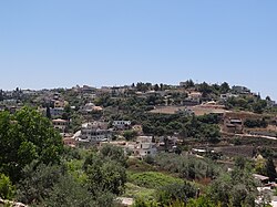
Daliyat al-Karmel
Daliat El Carmel
|
|
|---|---|
 |
|
| Coordinates: 32°41′35″N 35°02′58″E / 32.69306°N 35.04944°ECoordinates: 32°41′35″N 35°02′58″E / 32.69306°N 35.04944°E | |
| Grid position | 154/233 PAL |
| District | Haifa |
| Government | |
| • Type | Local council |
| • Head of Municipality | Rafik Halabi |
| Area | |
| • Total | 15,561 dunams (15.561 km2 or 6.008 sq mi) |
| Population (2015) | |
| • Total | 16,778 |
| Name meaning | "The hanging vine of Carmel |
| Website | www.Daliat-carmel.org.il |
Daliyat El Karmel (Arabic: دَالِيَةِ ٱلْكَرْمِل, Hebrew: דלית אל כרמל) is a Druze town in the Haifa District of Israel, located around 20 km southeast of Haifa. In 2015 its population was 16,778. Daliyat al-Karmel, situated on Mount Carmel, is the country’s largest and southernmost Druze town.
In 1283 both Daliyat al-Karmel and Kh. Doubel (just south of Daliyat al-Karmel) were mentioned as part of the domain of the Crusaders, according to the hudna between the Crusaders in Acre and the Mamluk sultan Qalawun.
In 1870 a local guide showed French explorer Victor Guérin extensive ruins located south of Daliyat al-Karmel, called Khirbet Doubel. The ruins were the most extensive on Mt. Carmel. Guérin thought it might be the town on Mt. Carmel mentioned by Pliny.Conder and Kitchener surveyed the area and noted "traces of ruins" at a place SE of the village centre called Dubil. Later excavations have found remains there from Iron Age I, Early Roman and Byzantine periods, together with pottery from first century to the second–third centuries CE.
In the 17th century, during the Ottoman period, Druze came from the hill country near Aleppo, Syria to Daliyat al-Karmel (lit. “Vine of the Carmel"), and in 1859 they were numbered by the English Consul Rogers to be 300 souls, who tilled twenty feddans.
...
Wikipedia

