Därligen
| Därligen | ||
|---|---|---|

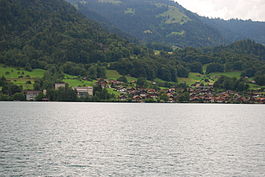
Därligen village on the shores of Lake Thun
|
||
|
||
| Coordinates: 46°39′N 7°48′E / 46.650°N 7.800°ECoordinates: 46°39′N 7°48′E / 46.650°N 7.800°E | ||
| Country | Switzerland | |
| Canton | Bern | |
| District | Interlaken-Oberhasli | |
| Government | ||
| • Mayor | Heinz Trittibach | |
| Area | ||
| • Total | 6.91 km2 (2.67 sq mi) | |
| Elevation | 567 m (1,860 ft) | |
| Population (Dec 2015) | ||
| • Total | 407 | |
| • Density | 59/km2 (150/sq mi) | |
| Postal code | 3707 | |
| SFOS number | 0575 | |
| Surrounded by | Interlaken, Matten bei Interlaken, Wilderswil, Saxeten and Leissigen | |
| Website |
www SFSO statistics |
|
Därligen is a municipality in the Interlaken-Oberhasli administrative district in the canton of Bern in Switzerland.
Därligen is first mentioned in 1244 as Tedningen.
The earliest traces of settlement in the area are scattered Bronze Age artifacts which have been discovered near the lake shore. The village was part of the Herrschaft of Unspunnen during the Middle Ages. It was annexed by Bern in 1515.
The Bödelibahn railway from Därligen to Interlaken opened in 1872 and was extended to Bönigen in 1874. Initially this line was unconnected to the rest of the Swiss railway system, and merely served as a link between the steamships on both lakes, with all goods and passengers transferred between boat and train at Därligen. However, in 1893, the line was extended westwards to Thun, with onward connections to Bern and beyond, thus removing the need for such transfer. The line eventually became part of the Bern–Lötschberg–Simplon railway.
Därligen lies in the Bernese Oberland at the south shore of Lake Thun. The town is located at the lake shore at the mouth of the Aare River canal, while the municipality reaches to the Därliggrat ridge. The town has a railway station.
Därligen has an area of 6.91 km2 (2.67 sq mi). Of this area, 1.35 km2 (0.52 sq mi) or 19.5% is used for agricultural purposes, while 4.52 km2 (1.75 sq mi) or 65.4% is forested. Of the rest of the land, 0.4 km2 (0.15 sq mi) or 5.8% is settled (buildings or roads), 0.03 km2 (7.4 acres) or 0.4% is either rivers or lakes and 0.55 km2 (0.21 sq mi) or 8.0% is unproductive land.
...
Wikipedia


