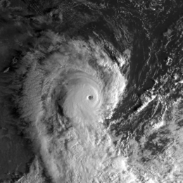
Cyclone Marcia
| Category 5 severe tropical cyclone (Aus scale) | |
|---|---|
| Category 4 (Saffir–Simpson scale) | |

Severe Tropical Cyclone Marcia at peak intensity on 19 February
|
|
| Formed | 15 February 2015 |
| Dissipated | 1 March 2015 |
| (Remnant low after 26 February) | |
| Highest winds |
10-minute sustained: 205 km/h (125 mph) 1-minute sustained: 230 km/h (145 mph) |
| Lowest pressure | 930 hPa (mbar); 27.46 inHg |
| Fatalities | None |
| Damage | $590.5 million (2015 USD) |
| Areas affected | Queensland |
| Part of the 2014–15 Australian region cyclone season | |
Severe Tropical Cyclone Marcia was a Category 5 severe tropical cyclone that made landfall at its peak strength over central Queensland, near Shoalwater Bay on 20 February 2015. The cyclone went on to affect various areas including Yeppoon and Rockhampton. It passed just to the west of Yeppoon as a Category 4 system, then traversed over the regional city of Rockhampton as a Category 2 system on the same day. Eventually, the cyclone weakened, moved southeast out to sea, then dissolved. Marcia caused at least A$750 million (US$590.5 million) worth of damage.
The Australian Bureau of Meteorology (BoM) started to monitor a tropical low which developed within the monsoon trough to the southeast of Papua New Guinea on 15 February. The system drifted generally eastwards and developed slowly under moderate vertical wind shear, until the Joint Typhoon Warning Center (JTWC) issued a Tropical Cyclone Formation Alert early on 17 February when deep convection wrapping tightly into a well-defined centre. Late on the same day, the BoM began to issue technical bulletins and designated the tropical low as 14U, although the bureau initially forecasted that it would only intensify into a category 1 cyclone prior to landfall. The JTWC upgraded the partially exposed system to a tropical cyclone and designated it as 13P early on 18 February, which also forecasted that it would intensify slightly. At 09Z, the BoM reported that the tropical low intensified into a category 1 tropical cyclone and named it Marcia, as it had started to track southwestwards along the northwestern periphery of a low- to mid-layered subtropical ridge.
When Marcia intensified into a category 2 tropical cyclone at 00:00 UTC on 19 February, it had developed a central dense overcast with a consolidating eyewall because of weakening vertical wind shear. Thanks to very good poleward outflow into the westerlies, Marcia dramatically underwent rapid intensification and formed a clear eye, becoming a category 3 severe tropical cyclone at 05:00 UTC and a category 4 system at 08:00 UTC. Soon afterwards, it turned southwards along the western periphery of a subtropical ridge and reached peak intensity at 18:00 UTC as a category 5 severe tropical cyclone with 10-minute maximum sustained winds at 205 km/h (125 mph), featuring a very well-defined 35 km (20 miles) eye. Maintaining strength, Marcia made landfall over the coast near Shoalwater Bay at 22:00 UTC (08:00 AEST on 20 February).
...
Wikipedia
