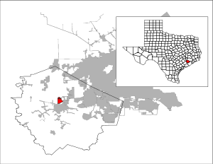
Cumings, Texas
| Cumings, Texas | |
|---|---|
| Census-designated place | |
 |
|
| Coordinates: 29°34′25″N 95°48′12″W / 29.57361°N 95.80333°WCoordinates: 29°34′25″N 95°48′12″W / 29.57361°N 95.80333°W | |
| Country | United States |
| State | Texas |
| County | Fort Bend |
| Area | |
| • Total | 2.92 sq mi (7.57 km2) |
| • Land | 2.80 sq mi (7.24 km2) |
| • Water | 0.12 sq mi (0.32 km2) |
| Elevation | 85 ft (26 m) |
| Population (2010) | |
| • Total | 981 |
| • Density | 351/sq mi (135.4/km2) |
| Time zone | Central (CST) (UTC-6) |
| • Summer (DST) | CDT (UTC-5) |
| FIPS code | 48-18134 |
| GNIS feature ID | 1852696 |
Cumings is an unincorporated community and census-designated place (CDP) in Fort Bend County, Texas, United States. The population was 981 at the 2010 census.
The town was established in the early 1990s.
Cumings is located north of the center of Fort Bend County at 29°34′25″N 95°48′12″W / 29.57361°N 95.80333°W (29.573483, -95.803286). It is bordered to the south and west by the city of Rosenberg. The southern and eastern edge of Cumings is the Brazos River.
According to the United States Census Bureau, the CDP has a total area of 2.9 square miles (7.6 km2), of which 2.8 square miles (7.2 km2) and 0.1 square miles (0.3 km2), or 4.25%, is water.
As of the census of 2000, there were 683 people, 172 households, and 156 families residing in the CDP. The population density was 225.6 people per square mile (87.0/km²). There were 186 housing units at an average density of 61.4 per square mile (23.7/km²). The racial makeup of the CDP was 60.76% White, 0.29% Asian, 35.43% from other races, and 3.51% from two or more races. Hispanic or Latino of any race were 91.65% of the population.
...
Wikipedia
