Cumbria Way
| Cumbria Way | |
|---|---|

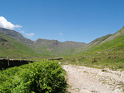
Cumbria Way leaves Langdale travelling alongside Mickleden Beck.
|
|
| Length | 112 km (70 mi) |
| Location | Cumbria, England |
| Trailheads |
Ulverston 54°11′42″N 3°05′31″W / 54.195°N 3.092°W Carlisle 54°53′42″N 2°56′02″W / 54.895°N 2.934°W |
| Use | Hiking |
| Elevation | |
| Highest point | High Pike 658 metres (2,159 ft) |
| Lowest point | Ulverston |
| Hiking details | |
| Trail difficulty | Moderate |
| Season | All year |
| Sights | Mountains, Tarns, Woodland |
| Hazards | Exposed sections, Weather |
The Cumbria Way is a linear long distance footpath in Cumbria, England passing through the towns of Coniston and Keswick. It also passes through the Langdale and Borrowdale valleys. The majority of the route is inside the boundaries of the Lake District National Park.
This 112 km route through the heart of the Lake District National Park links the two historic Cumbrian towns of Ulverston and Carlisle. The route cuts through classic Lakeland country via Coniston, Langdale, Borrowdale, Derwent Water, Skiddaw Forest and Caldbeck. It is a primarily low-level long distance footpath but does contain some high-level exposed sections.
The Cumbria Way was originally devised in the 1970s by local Ramblers' Association members. The waymarking of the entire route was completed by volunteers and national park staff in May 2007.
The route can be walked in either direction but is described here as south to north beginning at the trailhead of Ulverston (grid reference SD284785) and ending in Carlisle (grid reference NY400554).
...
Wikipedia
