Borrowdale
| Borrowdale | |
|---|---|
 Rosthwaite |
|
| Borrowdale shown within Cumbria | |
| Population | 417 (2011) |
| Civil parish |
|
| District | |
| Shire county | |
| Region | |
| Country | England |
| Sovereign state | United Kingdom |
| Post town | Keswick, Cumbria |
| Postcode district | CA12 5 |
| Dialling code | 017687 |
| Police | Cumbria |
| Fire | Cumbria |
| Ambulance | North West |
| EU Parliament | North West England |
| UK Parliament | |
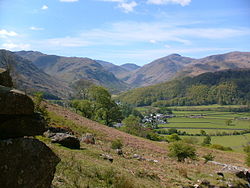
Borrowdale is a valley and civil parish in the English Lake District in the Borough of Allerdale in Cumbria, England.
Borrowdale lies within the historic county boundaries of Cumberland, and is sometimes referred to as Cumberland Borrowdale to distinguish it from another Borrowdale in the historic county of Westmorland.
The valley rises in the central Lake District and runs north carrying the River Derwent into the lake of Derwent Water. The waters of the River have their origins over a wide area of the central massif of the Lake District north of Esk Hause and Stake Pass, including draining the northern end of Scafell including Great End, the eastern side of the Dale Head massif, the western part of the Central Fells and all the Glaramara ridge. Near Rosthwaite the side valley of Langstrath joins the main valley from Seathwaite before the combined waters negotiate the narrow gap known as the Jaws of Borrowdale. Here it is flanked by the rocky crags of Castle Crag and Grange Fell. The valley then opens out around Grange before the river empties into Derwent Water, overlooked by Catbells, Skiddaw and Walla Crag.
The valley lends its name to the Borrowdale Volcanic Group, a geological development from the Ordovician period. This rock makes up most of the mountains at the head of Borrowdale, including Scafell Pike and Great Gable.
...
Wikipedia

