Cumbre Vieja
| Cumbre Vieja | |
|---|---|

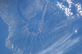
Satellite photo of Caldera de Taburiente and Cumbre Nueva, La Palma, Canary Islands (south is above, north is below).
|
|
| Highest point | |
| Elevation | 1,949 m (6,394 ft) |
| Coordinates | 28°34′N 17°50′W / 28.567°N 17.833°W |
| Geography | |
| Location |
La Palma, Canary Islands, |
| Geology | |
| Mountain type | Stratovolcano |
| Last eruption | 1971 |
Cumbre Vieja (Spanish: Old Summit) is an active although dormant volcanic ridge on the volcanic ocean island of Isla de La Palma in the Canary Islands, Spain, that erupted twice in the 20th century – in 1949, and again in 1971.
The ridge of the Cumbre Vieja trends in an approximate north-south direction and covers the southern two-thirds of the island. Several volcanic craters are located on the summit ridge and flanks.
La Palma is a volcanic ocean island, located on the African Plate and is currently - along with Tenerife, one of the most volcanically active of the Canary Islands. Historical eruptions on the Cumbre Vieja occurred in 1470, 1585, 1646, 1677, 1712, 1949 and 1971.
Since ~125 ka, all sub-aerial eruptive activity has been associated with the Cumbre Vieja with eruptions ranging over the whole ~25 kilometres long ridge. The Cumbre Vieja is known from submarine surveys to continue south of Punta de Fuencaliente (the Point of the Hot Fountain). Volcanic activity connected with the submarine extension has not been observed or recorded.
Detailed geological mapping shows that the distribution and orientation of vents and feeder dykes within the volcano have shifted from a triple rift system (typical of most volcanic ocean islands) to one consisting of a single north-south rift. It is hypothesised that this structural reorganisation is in response to evolving stress patterns associated with the development of a possible detachment fault under the volcano's west flank. Siebert (1984) showed that such failures are due to the intrusion of parallel and sub-parallel dykes into a rift. This causes the flanks to become over-steep and this inevitably causes the structure of the volcano to become unstable and catastrophic failure may occur. There is no evidence that the 1949 section of the rift extends in a north-south direction beyond its surface expression, nor that there is a developing detachment plane. Research is ongoing.
The onset of the eruption was witnessed by a shepherd who was tending sheep and goats on the flank of the Nambroque. He was startled to hear noises emanating from the Duraznero vent and became extremely alarmed when material started being expelled from the vent. In a state of panic he fled the area and sought refuge as far from the vent as he could. The only contemporaneous account of the eruption was published in 1950 by one of the scientists - Juan Bonelli-Rubio who witnessed the eruption first hand and recorded details of the various phenomena that occurred during the eruption. All other published accounts are based upon Bonelli-Rubio's observations. The next report regarding the eruption was a joint publication by Ortiz and Bonelli-Rubio published in 1951. This drew heavily on Bonelli-Rubio's observations and also analysis of various phenomena associated with the eruption. Both accounts are published in Spanish.
...
Wikipedia
