Cumberland Township, Greene County, Pennsylvania
| Cumberland Township, Greene County, Pennsylvania |
|
|---|---|
| Township | |

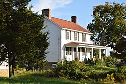
Farmhouse on Stevenson Lane
|
|
 Location of Cumberland Township in Greene County |
|
 Location of Greene County in Pennsylvania |
|
| Country | United States |
| State | Pennsylvania |
| County | Greene |
| Area | |
| • Total | 38.9 sq mi (100.8 km2) |
| • Land | 38.3 sq mi (99.1 km2) |
| • Water | 0.7 sq mi (1.7 km2) |
| Elevation | 1,000 ft (300 m) |
| Population (2010) | |
| • Total | 6,623 |
| • Estimate (2016) | 6,371 |
| • Density | 173/sq mi (66.8/km2) |
| Time zone | EST (UTC-4) |
| • Summer (DST) | EDT (UTC-5) |
| Area code(s) | 724 |
| FIPS code | 42-059-17648 |
Cumberland Township is a township in Greene County, Pennsylvania, United States. The population was 6,623 at the 2010 census.
The William Crawford House was listed on the National Register of Historic Places in 1992.
Cumberland Township is in eastern Greene County, with its eastern border following the center of the Monongahela River and forming the Fayette County line. The township surrounds the borough of Carmichaels, a separate municipality. The township includes the census-designated places of Crucible, Fairdale and Nemacolin. Other unincorporated communities in the township include Stringtown, Cumberland Village, Neil Corner, Baileys Crossroads, Khedive, Ceylon, Little Chicago, Paisley, and Live Easy.
According to the United States Census Bureau, the township has a total area of 38.9 square miles (100.8 km2), of which 38.3 square miles (99.1 km2) is land and 0.66 square miles (1.7 km2), or 1.66%, is water.
As of the census of 2000, there were 6,564 people, 2,659 households, and 1,834 families residing in the township. The population density was 171.7 people per square mile (66.3/km²). There were 2,893 housing units at an average density of 75.7/sq mi (29.2/km²). The racial makeup of the township was 98.58% White, 0.27% African American, 0.23% Native American, 0.02% Asian, 0.02% from other races, and 0.88% from two or more races. Hispanic or Latino of any race were 0.50% of the population.
...
Wikipedia
