Culver, Indiana
| Town of Culver, Indiana | |
|---|---|
| Town | |
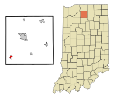
 Location in the state of Indiana |
|
| Coordinates: 41°13′2″N 86°25′18″W / 41.21722°N 86.42167°WCoordinates: 41°13′2″N 86°25′18″W / 41.21722°N 86.42167°W | |
| Country | United States |
| State | Indiana |
| County | Marshall |
| Township | Union |
| Area | |
| • Total | 0.90 sq mi (2.33 km2) |
| • Land | 0.90 sq mi (2.33 km2) |
| • Water | 0 sq mi (0 km2) |
| Elevation | 764 ft (233 m) |
| Population (2010) | |
| • Total | 1,353 |
| • Estimate (2012) | 1,380 |
| • Density | 1,503.3/sq mi (580.4/km2) |
| Time zone | EST (UTC-5) |
| • Summer (DST) | EDT (UTC-4) |
| ZIP code | 46511 |
| Area code(s) | 574 |
| FIPS code | 18-16300 |
| GNIS feature ID | 0433239 |
| Website | http://www.townofculver.org/ |
Culver is a town in Marshall County, Indiana, United States. Culver is part of Union Township that also includes the communities of Burr Oak, Hibbard, Maxinkuckee and Rutland. The population was 1,353 at the 2010 census.
Culver was originally called Union Town, and under the latter name was laid out in 1844. It was later renamed for the Henry Harrison Culver, head of the Culver Academies.
The Culver Commercial Historic District and Forest Place Historic District are listed on the National Register of Historic Places.
Culver is located at 41°13′2″N 86°25′18″W / 41.21722°N 86.42167°W (41.217340, -86.421726).
According to the 2010 census, Culver has a total area of 0.9 square miles (2.33 km2), all land.
As of the census of 2010, there were 1,353 people, 598 households, and 354 families residing in the town. The population density was 1,503.3 inhabitants per square mile (580.4/km2). There were 897 housing units at an average density of 996.7 per square mile (384.8/km2). The racial makeup of the town was 95.8% White, 1.2% African American, 0.4% Asian, 0.9% from other races, and 1.8% from two or more races. Hispanic or Latino of any race were 2.4% of the population.
...
Wikipedia
