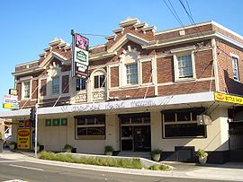
Croydon Park, New South Wales
|
Croydon Park Sydney, New South Wales |
|||||||||||||
|---|---|---|---|---|---|---|---|---|---|---|---|---|---|

Croydon Park Hotel
|
|||||||||||||
| Coordinates | 33°53′48″S 151°06′34″E / 33.89679°S 151.10951°ECoordinates: 33°53′48″S 151°06′34″E / 33.89679°S 151.10951°E | ||||||||||||
| Population | 10,742 (2011 census) | ||||||||||||
| Established | 1914 | ||||||||||||
| Postcode(s) | 2133 | ||||||||||||
| Location | 12 km (7 mi) SW of Sydney CBD | ||||||||||||
| LGA(s) | |||||||||||||
| State electorate(s) | Strathfield | ||||||||||||
| Federal Division(s) | Watson | ||||||||||||
|
|||||||||||||
Croydon Park is a suburb in the Inner West of Sydney, in the state of New South Wales, Australia. Croydon Park is about 12 kilometres south-west of the Sydney central business district and is divided between the local government areas of the Canterbury-Bankstown Council, Burwood Council and Inner West Council. Croydon is a separate suburb, to the north.
Croydon Park has a thriving commercial area along Georges River Road and is close to larger shopping areas in Burwood, Ashfield and Campsie. Croydon Park is a small residential suburb with many stores, particularly family owned such as Saba Hair Design, La Bocca Deli Cafe, Shisha Bar and Grill, Pure Gelato, Maranello's Veloce Italian Pizzeria, Renee's Pizzeria, Abla's pastry, ANAR Lebanese Charcoal Chicken, Little Thailand, Domino's, McDonald's, Subway, TAB, IGA, Croydon Park Chinese Restaurant, Croydon Park Petroleum, Croydon Park Hotel.
Croydon Park was originally part of the territory of the Darug tribe which occupied much of Sydney. More specifically, it was probably home to the Wangal clan (based around Concord) but may also have been home to the Cadigal (Sydney) or Bideagal (Botany Bay) clans. There were middens along the Cooks River where the indigenous people camped. These were destroyed by early British settlers to make lime for mortar in buildings.
In 1878 and 1880, following the building of a railway station at Croydon to the north, two large subdivisions of land were undertaken using the name Croydon Park. These constituted the entire area of the current suburb. A piece of flood-prone land at the junction of Croydon Avenue and the Cooks River was reserved as a public park. Given the name Croydon Park, it was the first reserve in the City of Canterbury. Early settlers included many people involved in the building trade and Chinese market gardeners.
...
Wikipedia
