Crows Nest, Indiana
| Town of Crows Nest, Indiana | |
|---|---|
| Town | |

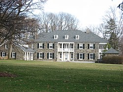
The former home of Eli Lilly is located in Crows Nest.
|
|
 Location in the state of Indiana |
|
| Coordinates: 39°51′8″N 86°10′22″W / 39.85222°N 86.17278°WCoordinates: 39°51′8″N 86°10′22″W / 39.85222°N 86.17278°W | |
| Country | United States |
| State | Indiana |
| County | Marion |
| Township | Washington |
| Area | |
| • Total | 0.43 sq mi (1.11 km2) |
| • Land | 0.43 sq mi (1.11 km2) |
| • Water | 0 sq mi (0 km2) |
| Elevation | 774 ft (236 m) |
| Population (2010) | |
| • Total | 73 |
| • Estimate (2012) | 74 |
| • Density | 169.8/sq mi (65.6/km2) |
| Time zone | EST (UTC-5) |
| • Summer (DST) | EST (UTC-5) |
| FIPS code | 18-16156 |
| GNIS feature ID | 0433220 |
| Website | |
|
Town of Crows Nest Historic District
|
|
| Location | Roughly bounded by Kessler Blvd., White R., and Questover Circle, Indianapolis |
| Area | 65 acres (26 ha) |
| Architectural style | Colonial Revival, Tudor Revival, et al. |
| NRHP Reference # | 00000305 |
| Added to NRHP | April 13, 2000 |
The Town of Crows Nest is located in Washington Township, Marion County, Indiana, approximately 7 miles (11 km) northwest of downtown Indianapolis. The town is adjacent to the neighboring community of North Crows Nest. It includes two streets: Sunset Lane south of Kessler Boulevard and Questover Circle. The population was 73 at the 2010 census. It has existed as an "included town" since 1970, when it was incorporated into Indianapolis as part of Unigov. It is part of Indianapolis, but retains a functioning town government under IC 36-3-1-11.
Crows Nest was founded in 1927, and supposedly named from crows nesting nearby.
Crows Nest is located at 39°51′8″N 86°10′22″W / 39.85222°N 86.17278°W (39.852208, -86.172811).
According to the 2010 census, Crows Nest has a total area of 0.43 square miles (1.11 km2), all land.
As of the census of 2010, there were 73 people, 34 households, and 28 families residing in the town. The population density was 169.8 inhabitants per square mile (65.6/km2). There were 38 housing units at an average density of 88.4 per square mile (34.1/km2). The racial makeup of the town was 97.3% White and 2.7% African American. Hispanic or Latino of any race were 1.4% of the population.
...
Wikipedia


