Crooked River (Oregon)
| Crooked River | |
|
The Crooked River in Smith Rock State Park
|
|
| Country | United States |
|---|---|
| State | Oregon |
| Counties | Jefferson, Deschutes, Crook |
| Tributaries | |
| - right | Beaver Creek, North Fork Crooked River, Ochoco Creek |
| City | Prineville |
| Source | South Fork Crooked River |
| - elevation | 4,775 ft (1,455 m) |
| - coordinates | 43°38′55″N 120°23′30″W / 43.64861°N 120.39167°W |
| Mouth | Deschutes River |
| - location | Lake Billy Chinook |
| - elevation | 1,950 ft (594 m) |
| - coordinates | 44°34′25″N 121°16′19″W / 44.57361°N 121.27194°WCoordinates: 44°34′25″N 121°16′19″W / 44.57361°N 121.27194°W |
| Length | 125 mi (201 km) |
| Basin | 4,500 sq mi (11,655 km2) |
| Discharge | for near mouth |
| - average | 1,544 cu ft/s (44 m3/s) |
| - max | 6,660 cu ft/s (189 m3/s) |
| - min | 656 cu ft/s (19 m3/s) |
|
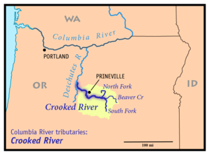
Map of the Crooked River watershed, its main tributaries and downriver connection to the Columbia River via the Deschutes River.
|
|
The Crooked River is a tributary, 125 miles (201 km) long, of the Deschutes River in the U.S. state of Oregon. The river begins at the confluence of the South Fork Crooked River and Beaver Creek. Of the two tributaries, the South Fork Crooked River is the larger and is sometimes considered part of the Crooked River proper. A variant name of the South Fork Crooked River is simply "Crooked River". The Deschutes River flows north into the Columbia River.
The South Fork Crooked River originates in an area called Misery Flat, along the Deschutes County, Lake County and Harney County boundaries, north of Glass Buttes. The South Fork's tributaries drain Hampton Buttes to the west and Mackey Butte to the east. The South Fork Crooked River flows north for 76 miles (122 km), collecting tributaries including Buck Creek and Twelvemile Creek before joining Beaver Creek to form the Crooked River proper near Paulina in Crook County.
Beaver Creek arises in two forks, North Fork and South Fork Beaver Creek, in Grant County. South Fork Beaver Creek drains the slopes of Snow Mountain and Funny Butte before joining the North Fork. Beaver Creek then flows west through Paulina Valley and is joined by Grindstone Creek just upstream from Paulina. Downstream of Paulina, Beaver Creek joins the South Fork Crooked River to form the Crooked River proper.
From the confluence of the South Fork and Beaver Creek, the Crooked River flows west, collecting the tributary Camp Creek from the south and then the North Fork Crooked River from the north. The North Fork Crooked River arises in Big Summit Prairie on the southern side of the Ochoco Mountains.
...
Wikipedia


