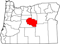
Crook County, Oregon
| Crook County, Oregon | |
|---|---|

Crook County Courthouse in Prineville
|
|
 Location in the U.S. state of Oregon |
|
 Oregon's location in the U.S. |
|
| Founded | October 24, 1882 |
| Seat | Prineville |
| Largest city | Prineville |
| Area | |
| • Total | 2,987 sq mi (7,736 km2) |
| • Land | 2,979 sq mi (7,716 km2) |
| • Water | 8.2 sq mi (21 km2), 0.3% |
| Population (est.) | |
| • (2015) | 21,630 |
| • Density | 7.0/sq mi (3/km²) |
| Congressional district | 2nd |
| Time zone | Pacific: UTC-8/-7 |
| Website | www |
Crook County is a county in the U.S. state of Oregon. As of the 2010 census, the population was 20,978. The county seat is Prineville. The county is named after George Crook, a U.S. Army officer who served in the American Civil War and various Indian Wars.
Crook County comprises the Prineville, OR Micropolitan Statistical Area, which is included in the Bend-Redmond-Prineville, OR Combined Statistical Area.
Crook County was established on October 9, 1882, by an act of the Oregon State Legislature. The county was named after General George Crook, a veteran of various battles against the indigenous peoples of Eastern Oregon in the middle of the 19th Century. The county was formed from territory formerly part of Wasco County, including the hilly region where the foothills of the Blue Mountains intersect the Cascade Mountain Range.
Access into the region at first was difficult, which discouraged settlement. The first effort to develop routes into the area was in 1862 when a supply train with cattle crossed the Scott Trail. This was also the first group of non-natives to spend the winter in central Oregon. The discovery and development of the Santiam Pass in the 1860s improved access into the area.
...
Wikipedia
